True world карты
True world карты
The True Size меняет картину мира, показывая истинный размер каждой страны
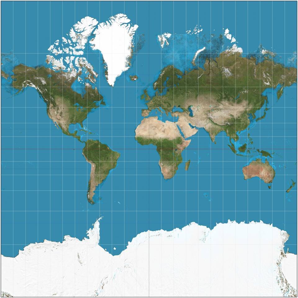
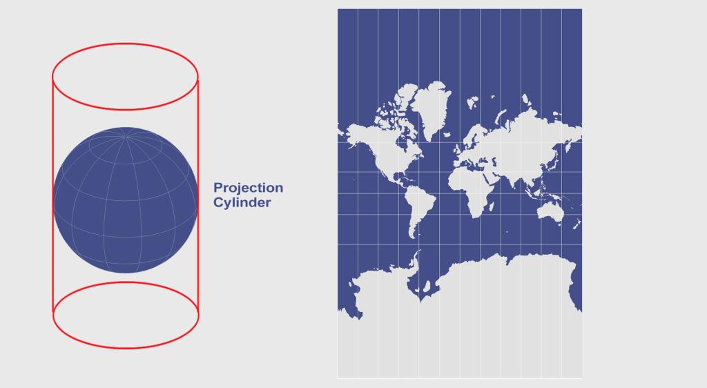
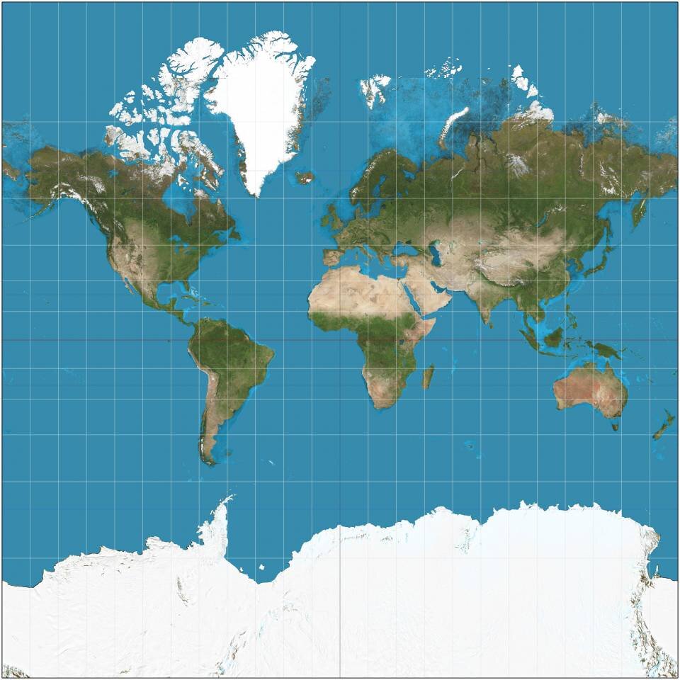
Метод картирования мира, разработанный в 16-м веке Герардом Меркатором, считался революционным. И в то же время он давал неверные представления о размерах стран и континентов многим поколениям людей. Сайт The True Size предлагает переосмыслить карту мира, связанную с цилиндрической проекцией Меркатора.
Разработчики ресурса пишут:
«Трудно отобразить наш сферический мир на плоском листе бумаги. Картографы используют так называемую «проекцию», чтобы превратить глобус в 2D карту. Наиболее популярная из них – проекция Меркатора.
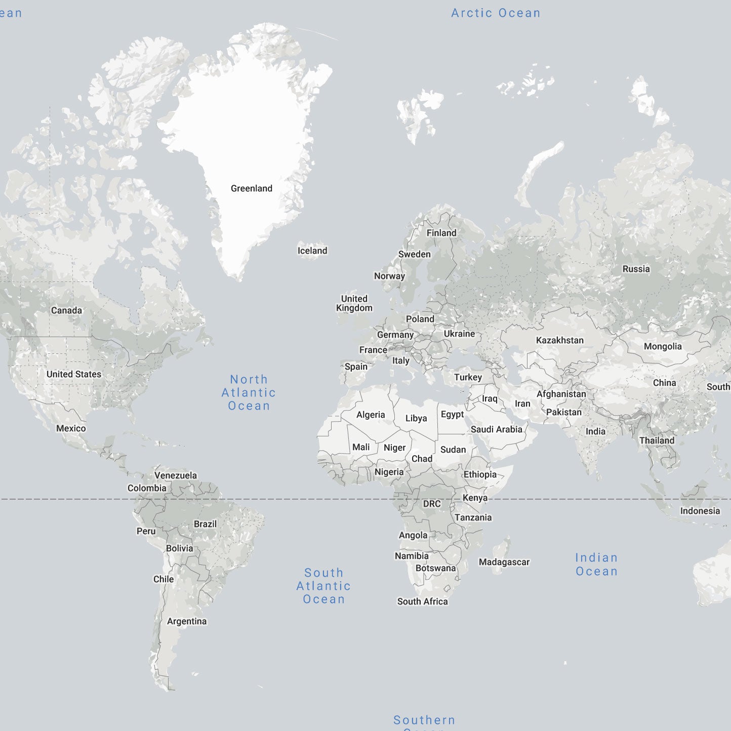
Каждая картографическая проекция несёт искажения, и у каждой свой набор проблем. Основная критика карты Меркатора связана с тем, что она не сохраняет площади, а преувеличивает размеры стран по мере приближения к полюсам (США, Россия, Европа), при этом уменьшая видимые размеры государств по мере приближения к экватору (Африканский континент). На проекции Меркатора Гренландия выглядит примерно такой же, как Африка. На самом деле площадь Гренландии составляет 2 130 800 квадратных километров, а площадь Африки 30 132 000 квадратных километров, то есть материк более чем в 14 раз крупнее острова».
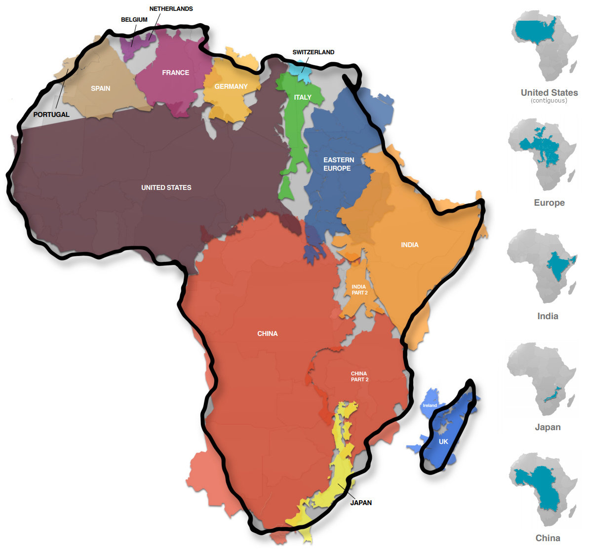
Создателей этого инструмента вдохновил эпизод фильма «Западное крыло» и инфографика Кая Краузе «Истинный размер Африки». Они выказали надежду, что преподаватели воспользуются их ресурсом, чтобы показать своим ученикам, насколько велик мир на самом деле.
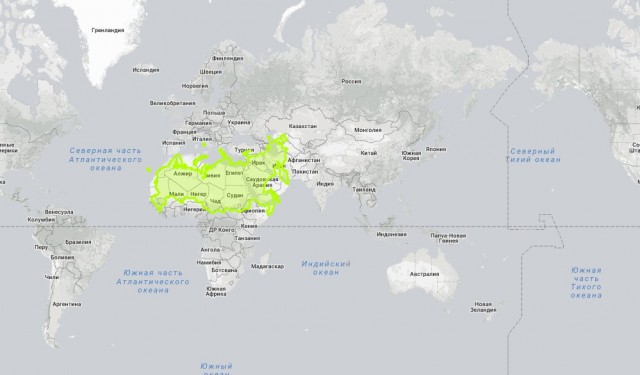
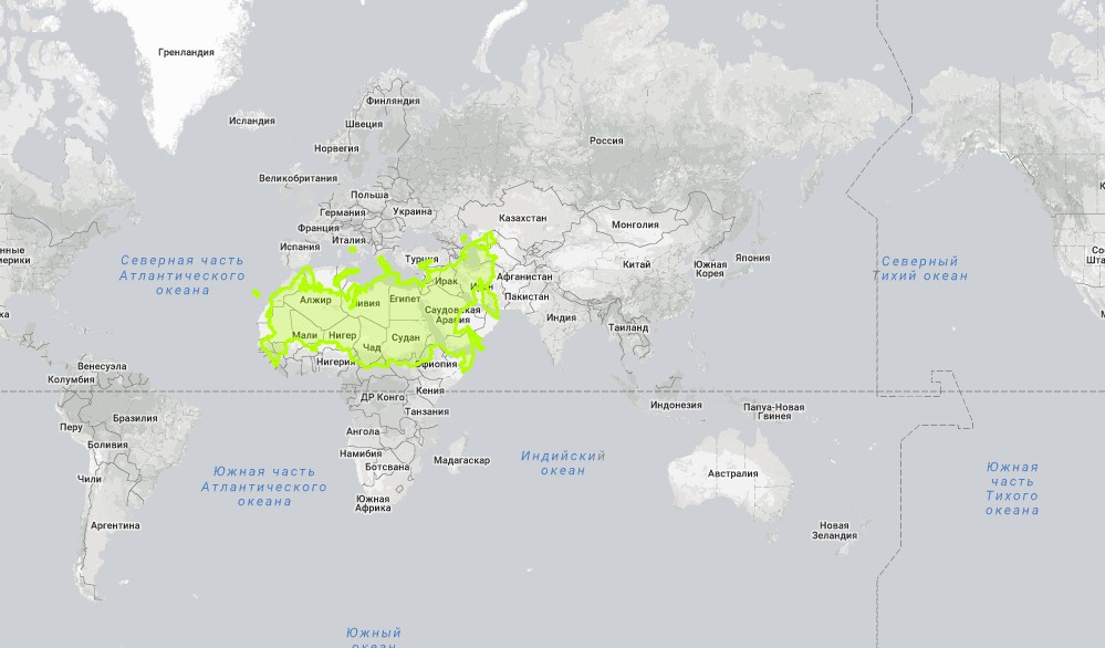
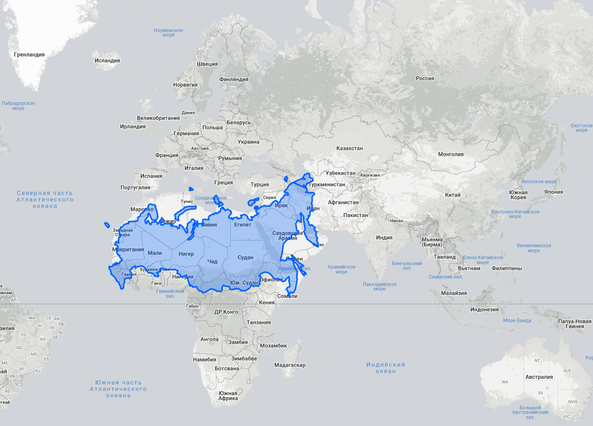
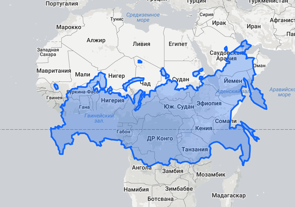
Россия – Западная Азия и Северная Африка:
Отрывок из сериала «Западное крыло» (2 сезон 16 серия) о том, что не так с картой мира от Меркатора.
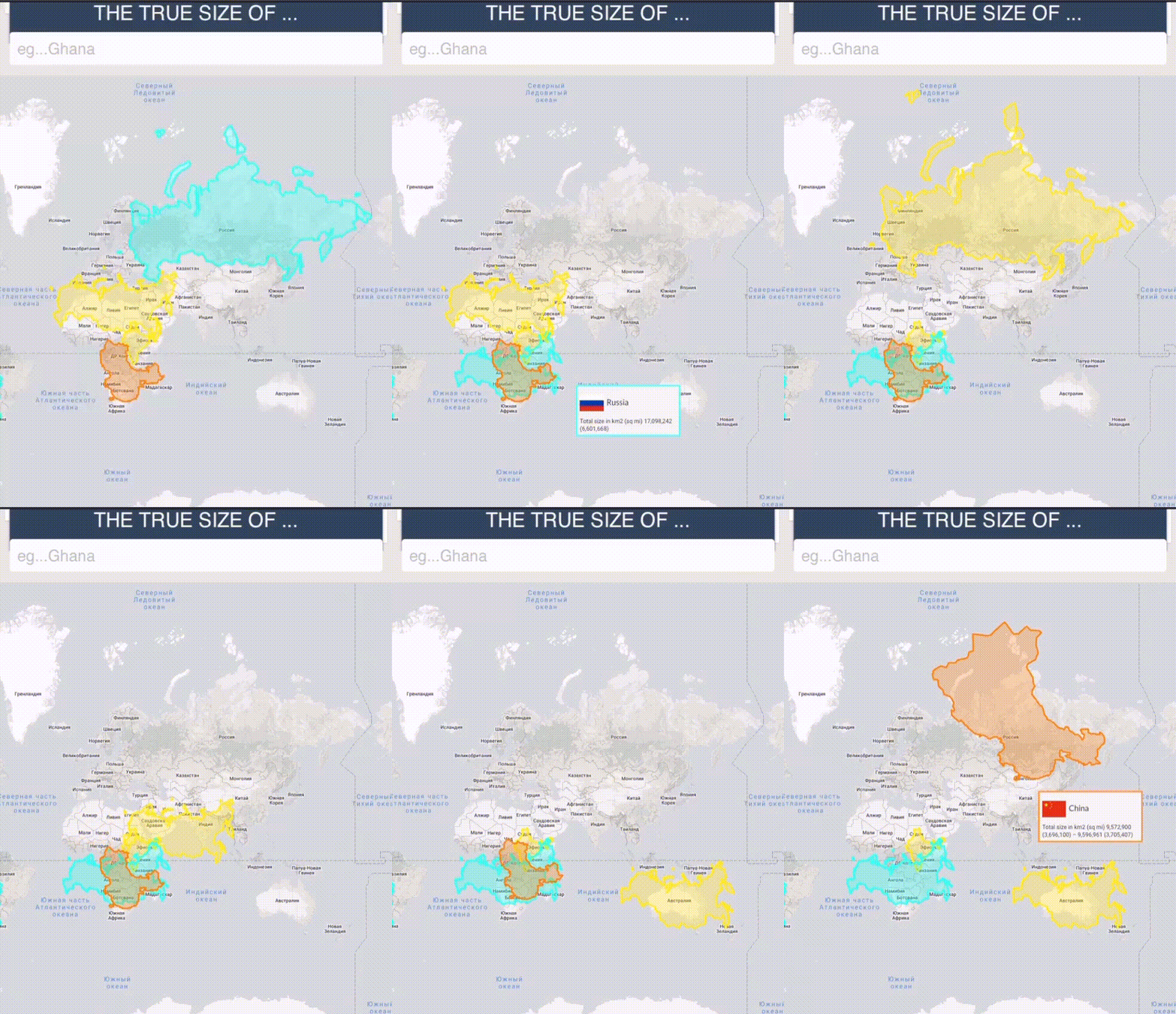
На сайте The True Size можно сравнить истинные размеры стран и убедиться в том, насколько искажены наши представления об их величине. Для этого в строке, расположенной вверху слева, нужно вписать название страны. Её границы выделятся цветом. Щёлкнув на них, перетащите её в любую часть мира. Интереснее всего сравнивать страны из разной широты. Например, если перенести Австралию вверх, то она охватит треть России, а если переместить Гренландию вниз, она не покроет даже Аргентину.
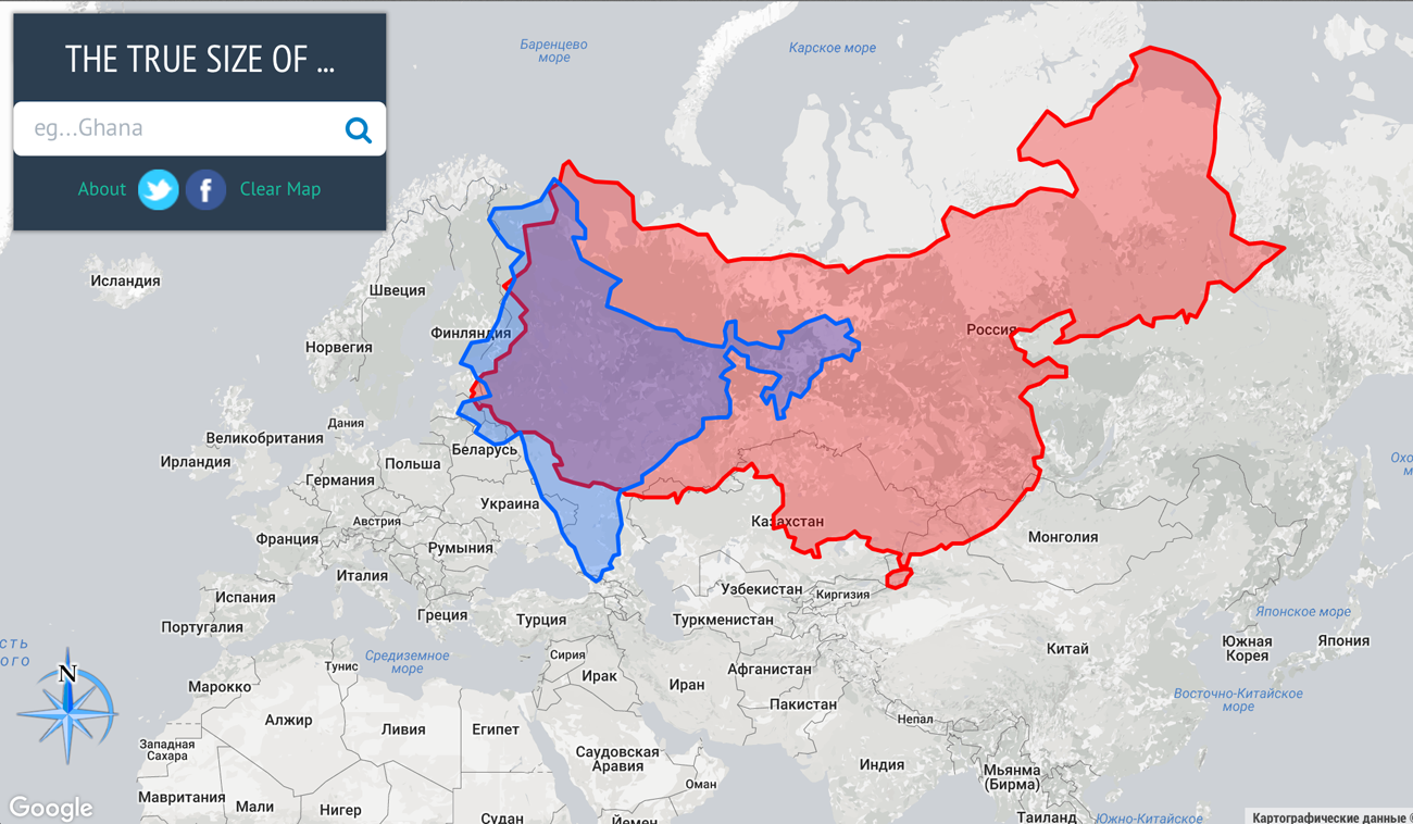
Вот так выглядит сравнение площади Россия – Австралия и Россия – США:
Скриншоты
Описание
Неужели Гренландия такая же большая, как вся Южная Америка?
Поскольку Земля представляет собой шар, невозможно точно показать ее на плоской карте. Так что все карты искажены.
С помощью этого простого приложения вы сможете сравнивать страны и знать, насколько они велики на самом деле.
Просто найдите или нажмите и удерживайте страну, которую хотите исследовать. После этого вы сможете перемещать его по карте и наблюдать, как он меняет размеры по мере приближения или отдаления от экватора.
Вы также узнаете несколько интересных фактов о выбранном месте.
Отличный инструмент для учителей, детей и взрослых, интересующихся географией.
История обновлений
Этот выпуск включает в себя множество улучшений и исправлений ошибок.
Пожалуйста, продолжайте присылать свои комментарии на адрес [email protected] Спасибо за поддержку!
Теперь вы сможете поворачивать страны с помощью компаса или жеста двумя пальцами.
на страну.
Этот выпуск включает в себя множество улучшений и исправлений ошибок.
Пожалуйста, продолжайте присылать свои комментарии на адрес [email protected]ldmaps.com. Спасибо за поддержку!
Теперь вы сможете поворачивать страны с помощью компаса или жеста двумя пальцами.
на страну.
Этот выпуск включает в себя множество улучшений и исправлений ошибок.
Пожалуйста, продолжайте присылать свои комментарии на адрес [email protected] Спасибо за поддержку!
Теперь вы сможете поворачивать страны с помощью компаса или жеста двумя пальцами.
на страну.
Этот выпуск включает в себя множество улучшений и исправлений ошибок.
Пожалуйста, продолжайте присылать свои комментарии на адрес [email protected] Спасибо за поддержку!
Теперь вы сможете поворачивать страны с помощью компаса или жеста двумя пальцами.
на страну.
Этот выпуск включает в себя множество улучшений и исправлений ошибок.
Пожалуйста, продолжайте присылать свои комментарии на адрес [email protected] Спасибо за поддержку!
TrueWorld Maps 4+
Compare countries real size
Emmanuel Teisaire
Designed for iPad
Screenshots
Description
Drag countries around to see their real size. You may be surprised!
Is really Greenland as big as all South America?
Because the Earth is a sphere, there is no way to show it perfectly on a flat map. So all maps are distorted.
With this simple app you will be able to compare countries and know how big they really are.
Simply search or tap and hold on the country you’d like to explore. You will then be able to move it around the map and watch it shift sizes as it gets closer to or farther from the equator.
You’ll also learn a few interesting facts about the selected place.
A great tool for teachers or kids and adults interested in geography.
Disclaimer about politics and partially recognised or disputed states:
The main purpose of this app is to have a notion of how big countries are. It’s not intending to perfectly reflect the limits nor the current political state of countries.
As such, we apologise for any political mistake that exists or that may exist in the future as territories evolve.
Mercator Misconceptions: Clever Map Shows the True Size of Countries
This Clever Map Shows the True Size of Countries
Maps are hugely important tools in our everyday life, whether it’s guiding our journeys from point A to B, or shaping our big picture perceptions about geopolitics and the environment.
For many people, the Earth as they know it is heavily informed by the Mercator projection—a tool used for nautical navigation that eventually became the world’s most widely recognized map.
Mercator’s Rise to the Top
With any map projection style, the big challenge lies in depicting a spherical object as a 2D graphic. There are various trade-offs with any map style, and those trade-offs can vary depending on how the map is meant to be used.
In 1569, the great cartographer, Gerardus Mercator, created a revolutionary new map based on a cylindrical projection. The new map was well-suited to nautical navigation since every line on the sphere is a constant course, or loxodrome.
Geographic Inflation
The vast majority of us aren’t using paper maps to chart our course across the ocean anymore, so critics of the Mercator projection argue that the continued use of this style of map gives users a warped sense of the true size of countries—particularly in the case of the African continent.
Mercator’s map inadvertently also pumps up the sizes of Europe and North America. Visually speaking, Canada and Russia appear to take up approximately 25% of the Earth’s surface, when in reality they occupy a mere 5%.
As the animated GIF below—created by Reddit user, neilrkaye – demonstrates, northern nations such as Canada and Russia have been artificially “pumped up” in the minds of many people around the world.
Greenland, which appears as a massive icy landmass in Mercator projection, shrinks way down. The continent of Africa takes a much more prominent position in this new, correctly-scaled map.
This visualization also highlights how distorted neighboring countries can look in Mercator projection. In the GIF above, Scandinavian countries no longer loom imposingly over their European neighbors, and Canada deflates to a size similar to the United States.
Despite inaccurate visual features—or perhaps because of them—the Mercator projection has achieved widespread adoption around the world. This includes in the classroom, where young minds are first learning about geography and forming opinions on the relationships between countries.
Getting Reacquainted with Globes
Google, whose map app is used by approximately 150 million people per month, took the bold step of using different projections for different purposes in 2018.
The Earth is depicted as a globe at further zoom levels, sidestepping map projection issues completely and displaying the world as it actually is: round. The result is a more accurate depiction of countries and landmasses.
With 3D Globe Mode on Google Maps desktop, Greenland’s projection is no longer the size of Africa.
At closer zoom levels, users are typically using maps for things like navigation, which the Mercator projection was designed for. The exact angles of roads and borders are preserved in this projection.
In the Right Direction
In a more globally connected world, geographic literacy is more important than ever. As people become more accustomed to equal area maps and seeing the Earth in its spherical form, misconceptions about the size of continents may become a thing of the past.
This post was first published in 2018. We have since updated it, adding in new content for 2021.
Создана первая точная карта мира. Что не так со всеми остальными?
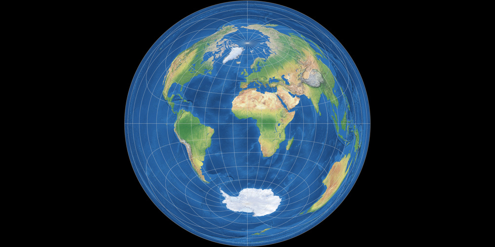
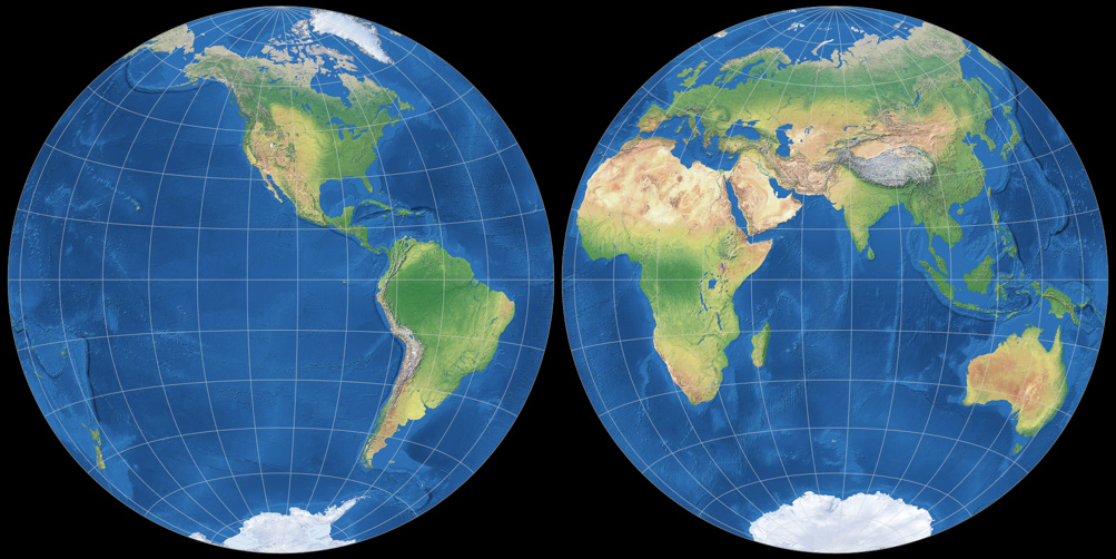
На привычных картах мир показан так, как его изобразил фламандский географ Герард Меркатор еще в XVI веке. Тогда он совершил революцию в картографии, но его проекция искажает реальные размеры стран. Все 2D-карты, которые существуют сегодня, неточные. Ученые решили сделать правильные плоские карты, однако они не похожи на то, что приходилось видеть ранее. Рассказываем о столетних попытках сделать правильные карты и показываем, сколько на самом деле места занимает Россия на земном шаре.
Читайте «Хайтек» в
Как показать круглую Землю?
Как выровнять сферу? На протяжении веков картографы пытались точно отобразить круглую планету на плоскости. Необходимо было создать карту, которую можно положить в карман и отправляться покорять новые территории, прорисовывать маршруты и вообще увидеть всю территорию Земли одновременно.
Попыток было много.
На привычных картах мир показан так, как его изобразил фламандский географ Герард Меркатор еще в XVI веке. Тогда он совершил революцию в картографии, но его проекция искажала реальные размеры стран (линии долготы расположены параллельно друг другу, хотя в реальности они пересекаются на полюсах, — в результате объекты у полюсов оказываются намного больше по размеру, чем те, что у экватора).
Однако невозможно сделать все идеально. Карта, на которой хорошо получается одно, может не подходить для изображения другого. Популярная проекция Меркатора, которая висит на всех стенах классных комнат и используемая в качестве основы для карт Google, превосходно отображает локальные формы, но она так сильно искажает участки поверхности вблизи Северного и Южного полюсов, что полярные регионы обычно просто обрезаются.
На карте True Size можно оценить это искажение: нужно выбрать любую страну, передвинуть ее на другой континент и сравнить масштабы. Например, на классической карте Россия выглядит в разы больше Африки, но в реальности она занимает только половину континента.
То же самое с Гренландией, которая, кажется, в два раза больше Австралии, — на деле же она занимает только треть ее площади. Китай, в свою очередь, занимает гораздо больше площади, чем кажется.
Попытки адаптации
Конечно, после создания проекции Меркатора ученые пытались сделать как можно более правдоподобную адаптацию. Как определить идеальную? В 2007 году была создана система для оценки существующих карт. Она количественно оценивает шесть типов искажений, которые вносят плоские карты: локальные формы, площади, расстояния, изгиб, асимметрия и граничные разрезы (разрывы непрерывности). Чем ниже оценка, тем лучше: у глобуса, например, оценка равна 0,0. Авторы системы — Дж. Ричард Готтом, заслуженный профессор астрофизики в Принстоне и создатель логарифмической карты Вселенной и Дэвид Голдберг, профессор физики в университете Дрекселя.
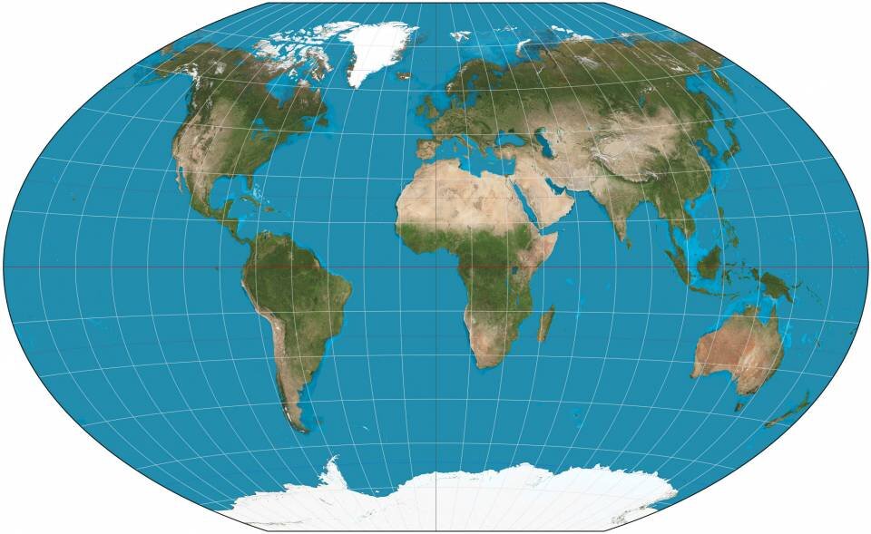
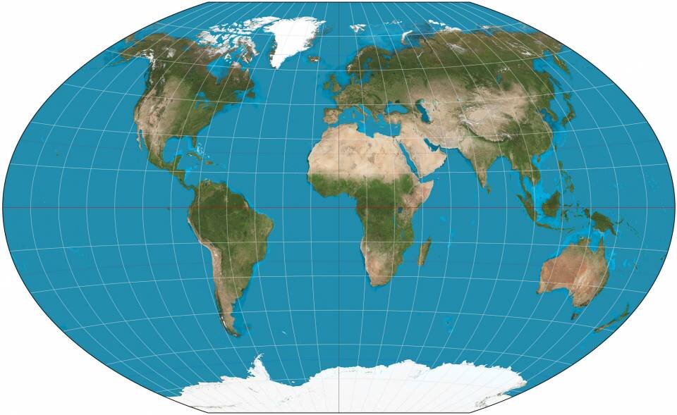
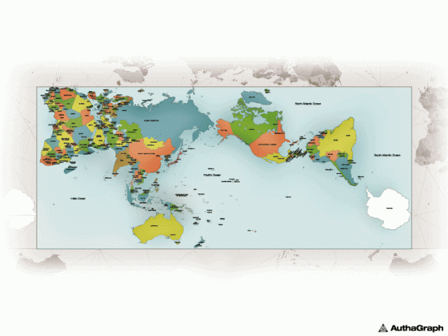
В 1921 году немецким картографом Освальдом Винкелем (Oswald Winkel) предложена модифицированная азимутальная проекция карты мира — проекция Винкеля lll (Winkel tripel projection). Это самая известная из ранее предложенных плоских картографических проекций. Название tripel (по-немецки «тройной») относится к цели Винкеля минимизировать три вида искажений: площадь, направление и расстояние.
Ее оценка по системе Голдберга-Готта равна 4,563. Уже близко к нулю, однако еще оставалась проблема «пересечения границ» — разделение Тихого океана и создание иллюзии большого расстояния между Азией и Гавайями.
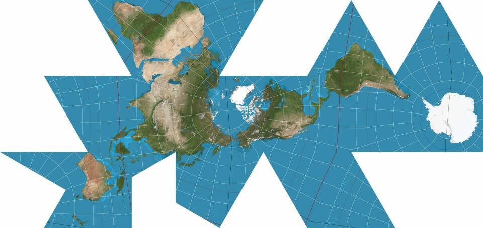
В 1943 году Бакминстер Фуллер попытался сделать карту, которая достоверно бы передавала размеры континентов. Он разбил круглую Землю на правильные формы и дал инструкции, как сложить и собрать земной шар в виде многогранного глобуса. Хотя таким образом Фуллер защитил формы континентов, он измельчил океаны, а многие между материками увеличились, например, между Австралией и Антарктидой.
Ясно, что нужен совершенно новый подход.
Новый подход
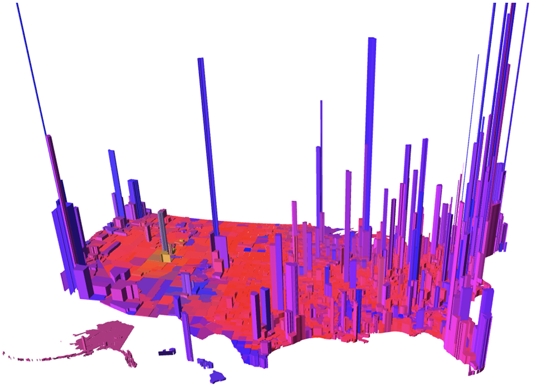
Фундаментальное переосмысление того, как могут работать карты, привело к созданию самой точной плоской карты из когда-либо созданных. В проекте принимали участие три эксперта: Дж. Ричард Готтом, Дэвид Голдберг и Роберт Вандербей, профессор операционных исследований и финансового инжиниринга, создавший карту результатов выборов «Пурпурная Америка».
Ученые вдохновились работой Готта о многогранниках — многогранных твердых фигурах. В недавней статье он начал рассматривать новый вид многогранников с правильными формами, что привело к революционной идее двусторонней карты.
Рассказывая о новой плоской карте профессор вспомнил историю с олимпийскими прыгунами в высоту. В 1968 году Дик Фосбери шокировал спортивных фанатов, выгнув спину и перепрыгнув через перекладину назад. Он установил новый рекорд и выиграл золотую медаль, и с тех пор прыгуны в высоту поменяли тактику.
«Мы как мистер Фосбери, — объясняет Готт. — Мы делаем это, чтобы побить рекорд, сделать плоскую карту с наименьшими возможными ошибками. Так что, как и он, мы удивляем людей, предлагаем кардинально другой вид карты. Каждая из ошибок Винкеля Трипеля была учтена».
Новая карта не похожа ни на одну из предыдущих.
Решение найдено
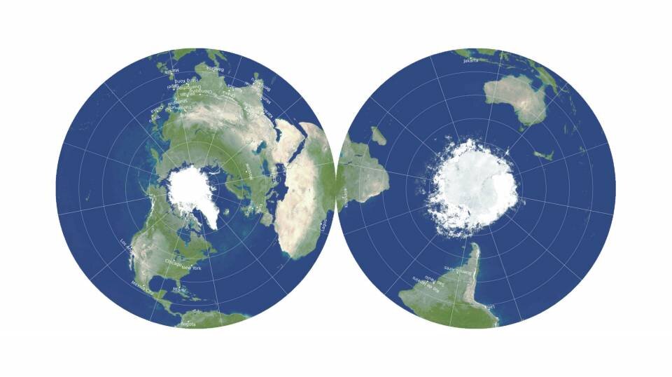
Плоская карта, которую создали ученые, двусторонняя и круглая, как граммофонная или виниловая пластинка. Она выходит за рамки двух измерений, не теряя при этом удобства логистики — хранения и изготовления — плоской карты.
Предоставлено: видео Дж. Ричарда Готта, Роберта Вандербеи и Дэвида Голдберга.
У новой двусторонней карты меньше ошибок в расстояниях, чем у любой односторонней плоской карты. Предыдущим рекордсменом была карта 2007 года, созданная Готтом с Чарльзом Муньоло, выпускником Принстона в 2005 году.
Фактически эта карта примечательна тем, что имеет верхнюю границу ошибок расстояния: отклонение расстояний более чем на ± 22,2% невозможно. Для сравнения, в проекциях Меркатора и Винкеля Трипеля, а также в других, ошибки расстояния становятся огромными по мере приближения к полюсам и по существу бесконечными от левого к правому краю (которые находятся далеко друг от друга на карте, но непосредственно примыкают к земному шару). Кроме того, площади на краю всего в 1,57 раза больше, чем в центре.
Карту можно распечатать спереди и сзади на одной странице журнала, чтобы читатель мог вырезать ее.
Насколько известно ученым, никто никогда раньше не делал двусторонние карты такой точности.
Eye-Opening “True Size Map” Shows the Real Size of Countries on a Global Scale
United States (blue), India (yellow), and China (orange)
When you picture a 2D representation of our world, what do you see? Chances are, you’re probably thinking of the Mercator map—a standard type of projection that’s been around since the late 16th century. Although it’s useful for navigational purposes, the map is also misleading because the relative sizes of countries are inaccurately conveyed. Some places, such as Greenland, look huge on this type of chart, but in actuality are much smaller. The opposite is true for places like China.
To uncover these often-stark differences, the True Size Map was created—a interactive website that allows you to drag countries and continents around the Mercator projection and discover just how big they are (or aren’t). You can do this for any country by simply typing its name into the map, allowing for a seemingly endless amount of comparisons.
This exercise is an eye-opening look at how this map might have affected our view on the world—concerns that were raised as far back as the early 20th century. “People’s ideas of geography are not founded on actual facts but on Mercator’s map,” British cartographer G. J. Morrison warned in 1902. Since its creation, however, cartographers have produced other ways to visualize the globe. And now, with the power of technology, endeavors like the True Size Map are also helping to change our size perceptions.
True Size: интерактивная карта мира с настоящими размерами стран
Размеры многих стран на картах на самом деле отличаются от привычных. IT-специалисты Джеймс Талмейдж и Дэймон Манис решили при помощи проекта True Size наглядно показать, как выглядит наша планета на самом деле. Об этом сообщается на сайте «Теории и практики».
На обычных картах мир показан так, как его изобразил фламандский географ Герард Меркатор в XVI веке. Он совершил революцию в картографии, но его проекция искажала реальные размеры стран. Это произошло из-за того, что линии долготы на карте расположены параллельно друг другу, хотя в реальности они пересекаются на полюсах. В результате объекты у полюсов оказываются намного больше по размеру, чем расположенные у экватора.
Карта True Size помогает оценить это искажение. На карте можно увидеть, что Россия выглядит намного больше Африки, но в реальности она занимает только половину континента. То же самое происходит и с Гренландией, которая кажется в два раза больше Австралии, но на самом деле занимает только треть её площади.
Ещё больше интересного и полезного про образование и воспитание — в нашем телеграм-канале. Подписывайтесь, чтобы ничего не пропустить!
TrueWorld Карты 4+
Сравнение размеров стран
Emmanuel Teisaire
Разработано для iPad
Снимки экрана
Описание
Перетащите страны, чтобы увидеть их реальный размер. Вы можете быть удивлены!
Неужели Гренландия такая же большая, как вся Южная Америка?
Поскольку Земля представляет собой шар, невозможно точно показать ее на плоской карте. Так что все карты искажены.
С помощью этого простого приложения вы сможете сравнивать страны и знать, насколько они велики на самом деле.
Просто найдите или нажмите и удерживайте страну, которую хотите исследовать. После этого вы сможете перемещать его по карте и наблюдать, как он меняет размеры по мере приближения или отдаления от экватора.
Вы также узнаете несколько интересных фактов о выбранном месте.
Отличный инструмент для учителей, детей и взрослых, интересующихся географией.
Проекции России на фоне других стран и континентов. Реальные размеры территории стран мира, интерактивная карта, сравнение размеров стран
Интерактивная карта «The true size map»: Проекции России на фоне других стран и континентов. Какие реальные размеры самой крупной по площади страны

https://oklah.net/wp-content/uploads/2019/10/singapore-size-min.jpg
Так например Россия, если верить политической карте изображенной выше, легко разместила бы на своей территории целый континент под названием Африка, а Гренландия, на северо-востоке Северной Америки, это поистине “исполинский материк”, но никак не остров. Однако, при помощи интернет ресурса “The true size of countries”, мы с вами легко сможем увидеть реальные размеры всех стран и континентов. Давайте рассмотрим размер России на фоне остальных материков, для лучшего понимания истинных размеров крупнейшей страны на планете.
Реальный размер России на фоне США
На фотографии ниже изображены реальные размеры Российской Федерации, на фоне Соединенных Штатов Америки и континента Северная Америка. Стоит учесть, что северная часть материка, не столь огромна, как нам может показаться на первый взгляд, опять же дело в искажении карт, при переносе геоида или шарообразной земли на плоскость. Для примера обратимся к следующей фотографии.
Проекции России на фоне других стран и континентов. Реальные размеры территории стран мира, интерактивная карта, сравнение размеров стран.
Разместим проекции России на фоне других стран, а так же континентов и посмотрим, какие реальные размеры самой крупной по площади страны на планете. Интерактивная карта для сравнения реальных размеров любых стран.
» data-medium-file=»https://i0.wp.com/enottravel.ru/wp-content/uploads/2020/10/8LKHToEqt8Q1-e1601640410255.jpg?fit=300%2C169&ssl=1″ data-large-file=»https://i0.wp.com/enottravel.ru/wp-content/uploads/2020/10/8LKHToEqt8Q1-e1601640410255.jpg?fit=800%2C450&ssl=1″ src=»https://i0.wp.com/enottravel.ru/wp-content/uploads/2020/10/8LKHToEqt8Q1.jpg?w=800&ssl=1″ alt=»Проекции России на фоне других стран. Реальные размеры территории стран мира, интерактивная карта, сравнение размеров стран/ Разместим проекции России на фоне других стран, а так же континентов и посмотрим, какие реальные размеры самой крупной по площади страны на планете. Интерактивная карта для сравнения реальных размеров любых стран.» title=»Сравнение размеров Россия на фоне США. Проекции России на фоне других стран. Реальные размеры территории стран мира, интерактивная карта, сравнение размеров стран» data-recalc-dims=»1″/> Сравнение размеров Россия на фоне США. Проекция России на фоне других стран. Реальные размеры территории стран мира, интерактивная карта, сравнение размеров стран
Реальный размер России на фоне Канады
При перетаскивании проекции России на уровень Канады, мы видим, как искажается форма нашей страны. Получается, что северная часть континента преувеличена чуть ли не а 2 раза.
Реальный размер России на фоне Южной Америки
Перейдем к континенту Южная Америка. Ее площадь, чуть больше площади нашей страны и равняется 17 840 000 кв. км. Из которых 8 511 000 кв. км. занимает крупнейшая на континенте страна — Бразилия.

Реальный размер России на фоне Африки
Следующая на очереди Африка, площадь которой составляет 30 370 000 кв. км. (второй по размеру материк после Евразии, с площадью 54 760 000 кв. км.). Как мы видим, разместить Россию на территории Африки не составит труда, если это конечно кому то нужно. Но никак не наоборот, уж очень сильно приуменьшен размер Африки на классической политической карте мира.

Реальный размер России на фоне Австралии
И в завершении нашего списка идет Австралия, затаившийся в правом нижнем углу непримечательный континент. Вот как выглядит проекция Российской Федерации на фоне Австралии. Площадь территории Австралии составляет 7 692 000 кв. км. Не такая уж и маленькая родина кенгуру.
Ссылка на интерактивную карту:
«The true size map»

After Seeing This Map With The Actual Size Of Every Country, You’ll Never Look At The World The Same
Probably most of us are familiar with the famous saying ‘my whole life was a lie,’ and we hate to tell you that, but it most likely was when it comes to the world map as we know it. Let’s just jump ahead and say there are no conspiracy theories here. It’s just not that simple laying out a globe on a flat piece of paper as in the Mercator map that we are all so familiar with. Good thing this climate data scientist took up the task of educating the masses on country size comparison and put up a map projection that shows real sizes together with those shown in regular maps. Even though his usual routines consist of analyzing various climate data and tracking climate change, geography is something tied closely together with his field of work. And if you follow him on social media, you will notice he has a genuine concern for environment and education, constantly filling his feed with various informational posts and interesting facts. In this particular map, he marked the true objects in the darker color and put them against a regular map so you can see the difference. Take a look at each continent on the planet and one extra treat – a supposedly huge island. Scroll down to see the true sized world map for yourself!
TrueWorld Карты 4+
Сравнение размеров стран
Emmanuel Teisaire
Разработано для iPad
Снимки экрана
Описание
Перетащите страны, чтобы увидеть их реальный размер. Вы можете быть удивлены!
Неужели Гренландия такая же большая, как вся Южная Америка?
Поскольку Земля представляет собой шар, невозможно точно показать ее на плоской карте. Так что все карты искажены.
С помощью этого простого приложения вы сможете сравнивать страны и знать, насколько они велики на самом деле.
Просто найдите или нажмите и удерживайте страну, которую хотите исследовать. После этого вы сможете перемещать его по карте и наблюдать, как он меняет размеры по мере приближения или отдаления от экватора.
Вы также узнаете несколько интересных фактов о выбранном месте.
Отличный инструмент для учителей, детей и взрослых, интересующихся географией.
TrueWorld Maps 4+
Compare countries real size
Emmanuel Teisaire
Designed for iPad
Screenshots
Description
Drag countries around to see their real size. You may be surprised!
Is really Greenland as big as all South America?
Because the Earth is a sphere, there is no way to show it perfectly on a flat map. So all maps are distorted.
With this simple app you will be able to compare countries and know how big they really are.
Simply search or tap and hold on the country you’d like to explore. You will then be able to move it around the map and watch it shift sizes as it gets closer to or farther from the equator.
You’ll also learn a few interesting facts about the selected place.
A great tool for teachers or kids and adults interested in geography.
Disclaimer about politics and partially recognised or disputed states:
The main purpose of this app is to have a notion of how big countries are. It’s not intending to perfectly reflect the limits nor the current political state of countries.
As such, we apologise for any political mistake that exists or that may exist in the future as territories evolve.
True world карты
This is the default welcome page used to test the correct operation of the Apache2 server after installation on Debian systems. If you can read this page, it means that the Apache HTTP server installed at this site is working properly. You should replace this file (located at /var/www/html/index.html) before continuing to operate your HTTP server.
If you are a normal user of this web site and don’t know what this page is about, this probably means that the site is currently unavailable due to maintenance. If the problem persists, please contact the site’s administrator.
Debian’s Apache2 default configuration is different from the upstream default configuration, and split into several files optimized for interaction with Debian tools. The configuration system is fully documented in /usr/share/doc/apache2/README.Debian.gz. Refer to this for the full documentation. Documentation for the web server itself can be found by accessing the manual if the apache2-doc package was installed on this server.
The configuration layout for an Apache2 web server installation on Debian systems is as follows:
By default, Debian does not allow access through the web browser to any file apart of those located in /var/www, public_html directories (when enabled) and /usr/share (for web applications). If your site is using a web document root located elsewhere (such as in /srv) you may need to whitelist your document root directory in /etc/apache2/apache2.conf.
The default Debian document root is /var/www/html. You can make your own virtual hosts under /var/www. This is different to previous releases which provides better security out of the box.
Please use the reportbug tool to report bugs in the Apache2 package with Debian. However, check existing bug reports before reporting a new bug.
Please report bugs specific to modules (such as PHP and others) to respective packages, not to the web server itself.
Карты TrueWorld
Скачать Карты TrueWorld 2.0.3 APK
ID: com.ment.truesize
Автор:
Версия:
Обновить:
Описание Карты TrueWorld
Карты TrueWorld
Действительно ли Гренландия такая же большая, как вся Южная Америка?
Поскольку Земля представляет собой шар, невозможно идеально изобразить ее на плоской карте. Так что все карты искажены.
С помощью этого простого приложения вы сможете сравнивать страны и узнавать, насколько они велики на самом деле.
Просто найдите или коснитесь и удерживайте страну, которую хотите исследовать. После этого вы сможете перемещать его по карте и наблюдать, как он меняет размеры по мере приближения или удаления от экватора.
Вы также узнаете несколько интересных фактов о выбранном месте.
Отличный инструмент для учителей, детей и взрослых, интересующихся географией.
Категория
Получите это:
Требования:
Карты TrueWorld 2.0.3 APK для Android 5.0+
| Версия | 2.0.3 для Android 5.0+ |
| Обновить | 2022-08-12 |
| Устанавливает | 1.000.000++ |
| Размер файла | 26.568.410 bytes |
| Разрешения | просматривать разрешения |
| Какие новости | Чередование стран: |
Теперь вы сможете чередовать страны с помощью компаса или жеста двумя пальцами
на стране.
Этот выпуск включает множество улучшений и исправлений ошибок.
Продолжайте присылать свои комментарии на адрес [email protected] Спасибо за вашу поддержку!
TrueWorld Maps 4+
Emmanuel Teisaire
Розроблено для iPad
Знімки екрана
Drag countries around to see their real size. You may be surprised!
Is really Greenland as big as all South America?
Because the Earth is a sphere, there is no way to show it perfectly on a flat map. So all maps are distorted.
With this simple app you will be able to compare countries and know how big they really are.
Simply search or tap and hold on the country you’d like to explore. You will then be able to move it around the map and watch it shift sizes as it gets closer to or farther from the equator.
You’ll also learn a few interesting facts about the selected place.
A great tool for teachers or kids and adults interested in geography.
Disclaimer about politics and partially recognised or disputed states:
The main purpose of this app is to have a notion of how big countries are. It’s not intending to perfectly reflect the limits nor the current political state of countries.
As such, we apologise for any political mistake that exists or that may exist in the future as territories evolve.
TrueWorld Maps 4+
Compare countries real size
Emmanuel Teisaire
Designed for iPad
Screenshots
Description
Drag countries around to see their real size. You may be surprised!
Is really Greenland as big as all South America?
Because the Earth is a sphere, there is no way to show it perfectly on a flat map. So all maps are distorted.
With this simple app you will be able to compare countries and know how big they really are.
Simply search or tap and hold on the country you’d like to explore. You will then be able to move it around the map and watch it shift sizes as it gets closer to or farther from the equator.
You’ll also learn a few interesting facts about the selected place.
A great tool for teachers or kids and adults interested in geography.
Disclaimer about politics and partially recognised or disputed states:
The main purpose of this app is to have a notion of how big countries are. It’s not intending to perfectly reflect the limits nor the current political state of countries.
As such, we apologise for any political mistake that exists or that may exist in the future as territories evolve.
Mapped: Visualizing the True Size of Africa
February 19, 2020
Mapped: The True Size of Africa
Take a look at any map, and it’s clear that the African continent is a big place.
However, despite the common perception that Africa is a large landmass, it’s still one that is vastly underestimated by most casual map viewers.
The reason for this is that the familiar Mercator map projection tends to distort our geographical view of the world in a crucial way — one that often leads to misconceptions about the relative sizes of both countries and continents.
A Geographical Jigsaw
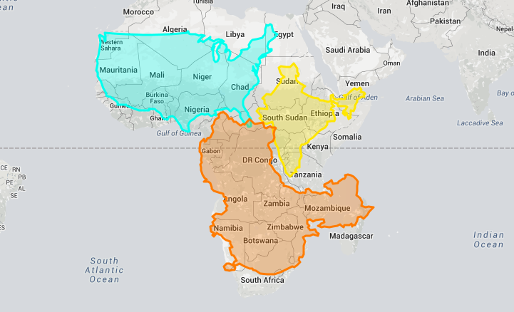
Today’s infographic comes from Kai Krause and it shows the true size of Africa, as revealed by the borders of the countries that can fit within the continent’s shape.
The African continent has a land area of 30.37 million sq km (11.7 million sq mi) — enough to fit in the U.S., China, India, Japan, Mexico, and many European nations, combined.
| Country | Land Area (sq. km) | Land Area (sq. mi) | % of Africa |
|---|---|---|---|
| 🇺🇸 United States | 9.83 million | 3.80 million | 32.4% |
| 🇨🇳 China | 9.60 million | 3.71 million | 31.6% |
| 🇮🇳 India | 3.29 million | 1.27 million | 10.8% |
| 🇲🇽 Mexico | 1.96 million | 0.76 million | 6.5% |
| 🇵🇪 Peru | 1.29 million | 0.50 million | 4.2% |
| 🇫🇷 France | 0.64 million | 0.25 million | 2.1% |
| 🇪🇸 Spain | 0.51 million | 0.20 million | 1.7% |
| 🇵🇬 Papua New Guinea | 0.46 million | 0.18 million | 1.5% |
| 🇸🇪 Sweden | 0.45 million | 0.17 million | 1.5% |
| 🇯🇵 Japan | 0.38 million | 0.15 million | 1.3% |
| 🇩🇪 Germany | 0.36 million | 0.14 million | 1.2% |
| 🇳🇴 Norway | 0.32 million | 0.13 million | 1.1% |
| 🇮🇹 Italy | 0.30 million | 0.12 million | 1.0% |
| 🇳🇿 New Zealand | 0.27 million | 0.10 million | 0.9% |
| 🇬🇧 United Kingdom | 0.24 million | 0.09 million | 0.8% |
| 🇳🇵 Nepal | 0.15 million | 0.06 million | 0.5% |
| 🇧🇩 Bangladesh | 0.15 million | 0.06 million | 0.5% |
| 🇬🇷 Greece | 0.13 million | 0.05 million | 0.4% |
| Total | 30.33 million sq. km | 11.71 million sq. mi | 99.9% |
You could add together all of the landmasses above and they would not equate to the geographical footprint of Africa, which itself is home to 54 countries and 1.2 billion people.
Editor’s note: The above table is slightly different from the countries shown in the visualization, which focuses more on fitting recognizable country shapes into the geographical shape of Africa.
Why the Misconception?
Interestingly, the problem with maps is not that Africa is sized incorrectly.
Using the animation below, you’ll see that Africa is actually the most accurately sized continent using the common Mercator map projection:
The Mercator projection attempts to place the spherical shape of the world onto a cylinder, causing areas closest to the poles to be “stretched”.
Africa, which straddles the Equator, barely changes in size — meanwhile, the countries furthest from the Equator become inflated from their true sizes on this type of map.
For those of us living in Western countries, this is an interesting dilemma to consider.
This means that the sizes of European and North American countries are distorted, giving us an inaccurate mental “measuring stick” for judging the relative sizes of other countries.
This has implications not only for Africa, but for the whole Southern Hemisphere: South America, India, the Middle East, and even Australia are “bigger” than they may initially appear on a map.
TrueWorld Maps 4+
Compare countries real size
Emmanuel Teisaire
Designed for iPad
Screenshots
Description
Drag countries around to see their real size. You may be surprised!
Is really Greenland as big as all South America?
Because the Earth is a sphere, there is no way to show it perfectly on a flat map. So all maps are distorted.
With this simple app you will be able to compare countries and know how big they really are.
Simply search or tap and hold on the country you’d like to explore. You will then be able to move it around the map and watch it shift sizes as it gets closer to or farther from the equator.
You’ll also learn a few interesting facts about the selected place.
A great tool for teachers or kids and adults interested in geography.
Disclaimer about politics and partially recognised or disputed states:
The main purpose of this app is to have a notion of how big countries are. It’s not intending to perfectly reflect the limits nor the current political state of countries.
As such, we apologise for any political mistake that exists or that may exist in the future as territories evolve.
True world карты
Товар был добавлен в корзину!
Ваш заказ принят, спасибо!
Ошибка оформления заказа!
Свяжитесь с нами!
+7 (495) 133-64-81
Будни с 11:00 до 19:00
Скретч карта горнолыжных курортов мира. История снежных путешествий.
Стирающаяся карта мира для отметок путешествий.
История семейного древа в фотографиях.
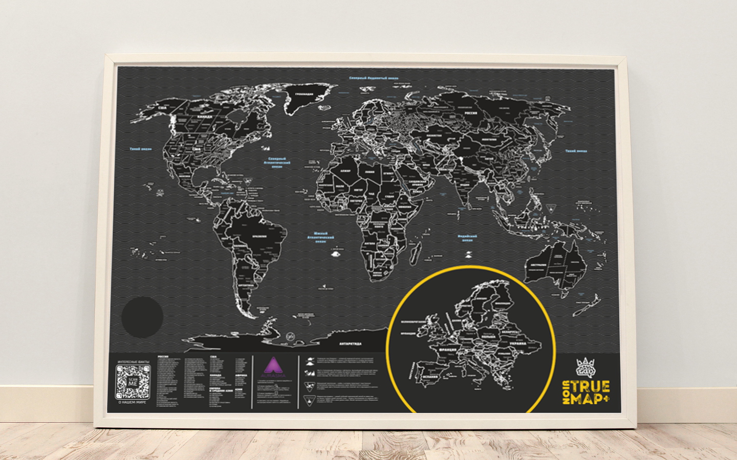
Первая карта мира с черным стирающимся слоем для отметок путешествий.
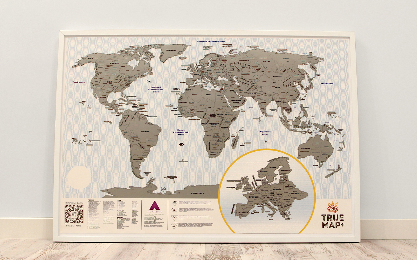
Самая большая и подробная стирающаяся карта мира для отметок путешествий.
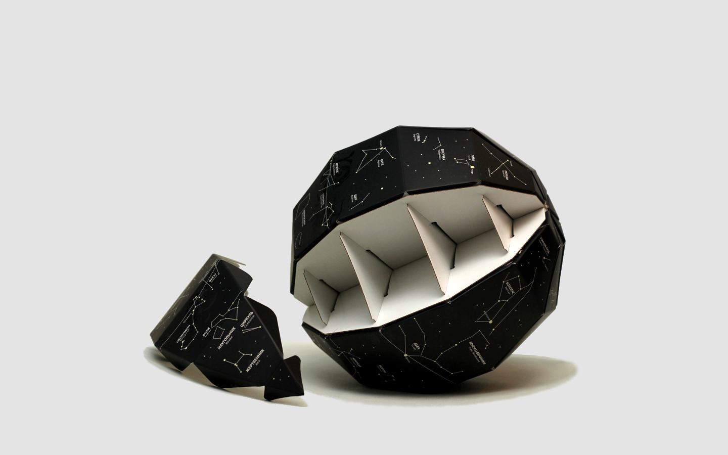
Глобус звездного неба светящийся в темноте
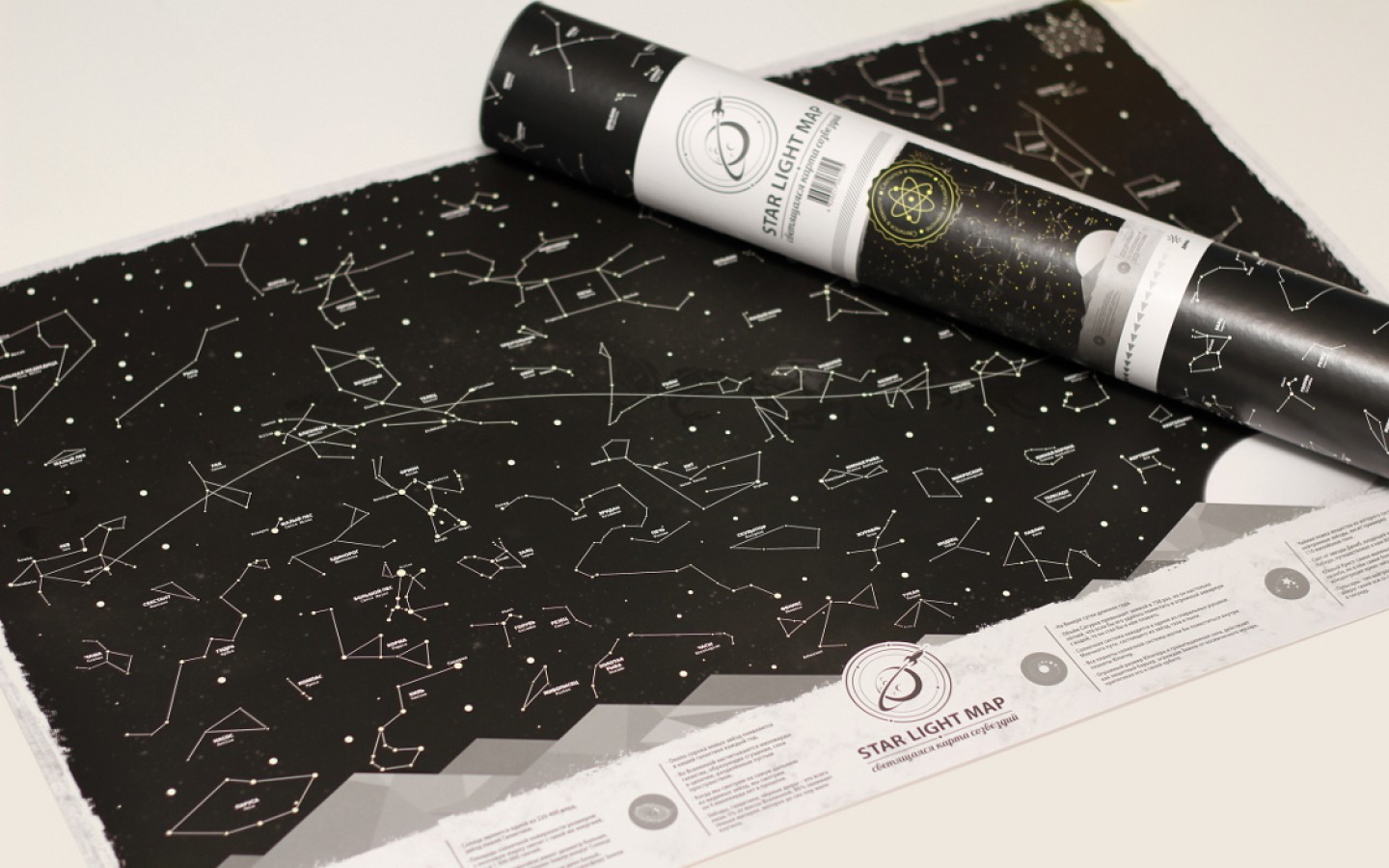
Карта звездного неба светящаяся в темноте.
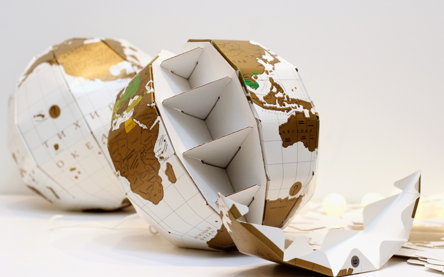
Глобус со скретч слоем для отметок путешествий.
Каждая карта из серии True Map имеет свои особенности и отличия:
TrueWorld Карты 4+
Сравнение размеров стран
Emmanuel Teisaire
Разработано для iPad
Снимки экрана
Описание
Перетащите страны, чтобы увидеть их реальный размер. Вы можете быть удивлены!
Неужели Гренландия такая же большая, как вся Южная Америка?
Поскольку Земля представляет собой шар, невозможно точно показать ее на плоской карте. Так что все карты искажены.
С помощью этого простого приложения вы сможете сравнивать страны и знать, насколько они велики на самом деле.
Просто найдите или нажмите и удерживайте страну, которую хотите исследовать. После этого вы сможете перемещать его по карте и наблюдать, как он меняет размеры по мере приближения или отдаления от экватора.
Вы также узнаете несколько интересных фактов о выбранном месте.
Отличный инструмент для учителей, детей и взрослых, интересующихся географией.
TrueWorld Maps 4+
Compare countries real size
Emmanuel Teisaire
Designed for iPad
Screenshots
Description
Drag countries around to see their real size. You may be surprised!
Is really Greenland as big as all South America?
Because the Earth is a sphere, there is no way to show it perfectly on a flat map. So all maps are distorted.
With this simple app you will be able to compare countries and know how big they really are.
Simply search or tap and hold on the country you’d like to explore. You will then be able to move it around the map and watch it shift sizes as it gets closer to or farther from the equator.
You’ll also learn a few interesting facts about the selected place.
A great tool for teachers or kids and adults interested in geography.
Disclaimer about politics and partially recognised or disputed states:
The main purpose of this app is to have a notion of how big countries are. It’s not intending to perfectly reflect the limits nor the current political state of countries.
As such, we apologise for any political mistake that exists or that may exist in the future as territories evolve.
True Scale Map of the World Shows How Big Countries Really Are
Think about a map of the world. The image you’re picturing will most likely resemble the Mercator projection—a 2D representation of the globe created in the 1500s which most maps you commonly come across are based on.
But despite its ubiquity, the Mercator projection does not accurately reflect the true size of countries given the impossibility of representing a 3D object on a 2D surface. In fact, the projection distorts the size of objects as the latitude increases from the equator to the poles, where the scale becomes infinite.
Animating the Mercator projection to the true size of each country in relation to all the others.
In order to more accurately depict the size of the countries, Neil Kaye, a climate scientist from the U.K. Met Office, has created a visualization of the Mercator projection in which countries morph into their true size.
«Each country is projected to the spherical projection and placed at the center of where it appears in the Natural Earth projection,» Kaye wrote in a Reddit post in reference to his creation. «There was then some manual tweaking of countries that are closer to the poles. This demonstrates you can’t fit shapes on a sphere back together again once you put them on the flat.»
The visualization clearly reveals how landmasses near the poles in the Mercator projection appear much larger than they actually are, relative to those nearer the equator.
For example: Antarctica appears as the biggest continent, despite it being the fifth largest in area; Alaska takes up as much area on the map as Brazil when, in reality, the South American nation’s area is almost five times that of the U.S. state; Greenland appears larger than Africa, when Africa is actually 14 times greater in size; and Africa also appears to be about the same size as Europe when it is almost three times larger.
The Mercator projection was first introduced by the Flemish cartographer Gerardus Mercator in 1569. Despite its drawbacks, the projection became the standard map for nautical navigation because it enables navigators to plot a straight-line course and is still widely used for this purpose.
The projection has long faced criticism because of its alleged Eurocentrism with both Europe and North America appearing much larger than they actually are in comparison to Africa and South America. According to critics, this reinforces the myth of white exceptionalism and depicts a view of the world rooted in the history of colonialism.
Because of this and the distortions present in the Mercator projection, some people favor other representations, such as the Gall-Peters projection, although each of these has their own set of flaws. For example, the Gall-Peters projection—which is widely used in educational and business circles—shows the correct size of countries and continents in relation to each other but it’s stretched out at the equator and squashed towards the poles.
TrueWorld Maps 4+
Compare countries real size
Emmanuel Teisaire
Designed for iPad
Screenshots
Description
Drag countries around to see their real size. You may be surprised!
Is really Greenland as big as all South America?
Because the Earth is a sphere, there is no way to show it perfectly on a flat map. So all maps are distorted.
With this simple app you will be able to compare countries and know how big they really are.
Simply search or tap and hold on the country you’d like to explore. You will then be able to move it around the map and watch it shift sizes as it gets closer to or farther from the equator.
You’ll also learn a few interesting facts about the selected place.
A great tool for teachers or kids and adults interested in geography.
Disclaimer about politics and partially recognised or disputed states:
The main purpose of this app is to have a notion of how big countries are. It’s not intending to perfectly reflect the limits nor the current political state of countries.
As such, we apologise for any political mistake that exists or that may exist in the future as territories evolve.
Реальные размеры стран на карте мира
Интересный проект отыскала наша редакция на днях в сети. Сервис позволяет сравнить реальные размеры стран мира на карте.
Вас никогда не удивляло, что Гренландия на картах размером как целая Африка и вдвое больше Австралии и при этом зовется островом? На самом же деле, на географических картах просто внесены геометрические искажения, ведь наша Земля круглая, а карта мира плоская, как результат, большинство стран расположенных в Северном и Южном полушариях на карте выглядят значительно больше чем есть на самом деле, к слову, Россия не исключение — в примере выше как раз показано реальное соотношение размеров России и Индии.
Сервис The True Size Of позволяет увидеть и, при этом, еще и сравнить реальные размеры любой из стран. На практике может и не сильно полезно, зато познавательно и увлекательно.
Как пользоваться? Все просто. В строке поиска набираете название страны и нажимаете enter, после чего она подсвечивается на карте. Мышкой же можно перетащить контур выбранной страны на любое место на карте, совместив, таким образом, положение нескольких государств — попробуйте проделать это с Россией, перетянув ее на экватор — визуально размеры уменьшатся втрое.
А еще сервис дает информацию о площади и даже показывает национальный флаг — определенно, любителям географии понравится.
TrueWorld Maps +4
Compare countries real size
Emmanuel Teisaire
Designed for iPad
Screenshots
Description
Drag countries around to see their real size. You may be surprised!
Is really Greenland as big as all South America?
Because the Earth is a sphere, there is no way to show it perfectly on a flat map. So all maps are distorted.
With this simple app you will be able to compare countries and know how big they really are.
Simply search or tap and hold on the country you’d like to explore. You will then be able to move it around the map and watch it shift sizes as it gets closer to or farther from the equator.
You’ll also learn a few interesting facts about the selected place.
A great tool for teachers or kids and adults interested in geography.
Disclaimer about politics and partially recognised or disputed states:
The main purpose of this app is to have a notion of how big countries are. It’s not intending to perfectly reflect the limits nor the current political state of countries.
As such, we apologise for any political mistake that exists or that may exist in the future as territories evolve.
TrueWorld Карты Взлом 2.0.3 + Чит Коды
Сравнение размеров стран
Скриншоты

Описание
Перетащите страны, чтобы увидеть их реальный размер. Вы можете быть удивлены!
Неужели Гренландия такая же большая, как вся Южная Америка?
Поскольку Земля представляет собой шар, невозможно точно показать ее на плоской карте. Так что все карты искажены.
С помощью этого простого приложения вы сможете сравнивать страны и знать, насколько они велики на самом деле.
Просто найдите или нажмите и удерживайте страну, которую хотите исследовать. После этого вы сможете перемещать его по карте и наблюдать, как он меняет размеры по мере приближения или отдаления от экватора.
Вы также узнаете несколько интересных фактов о выбранном месте.
Отличный инструмент для учителей, детей и взрослых, интересующихся географией.
История обновлений
Этот выпуск включает в себя множество улучшений и исправлений ошибок.
Пожалуйста, продолжайте присылать свои комментарии на адрес [email protected] Спасибо за поддержку!
Теперь вы сможете поворачивать страны с помощью компаса или жеста двумя пальцами.
на страну.
Этот выпуск включает в себя множество улучшений и исправлений ошибок.
Пожалуйста, продолжайте присылать свои комментарии на адрес [email protected] Спасибо за поддержку!
Теперь вы сможете поворачивать страны с помощью компаса или жеста двумя пальцами.
на страну.
Этот выпуск включает в себя множество улучшений и исправлений ошибок.
Пожалуйста, продолжайте присылать свои комментарии на адрес [email protected] Спасибо за поддержку!
Теперь вы сможете поворачивать страны с помощью компаса или жеста двумя пальцами.
на страну.
Этот выпуск включает в себя множество улучшений и исправлений ошибок.
Пожалуйста, продолжайте присылать свои комментарии на адрес [email protected] Спасибо за поддержку!
What if we told you that your whole perception of our world has been a lie?
Image from www.me.me
Umm… huh? Yeah. If you’re utterly confused by this meme then don’t worry, read on and we’ll explain everything!
In this blog post you’ll find answers to these questions:
1. Why is the world map we all know «incorrect»?
2. What are the real sizes of countries?
3. Are there any world maps where you can see the true sizes of countries?
Let’s get it started with this!
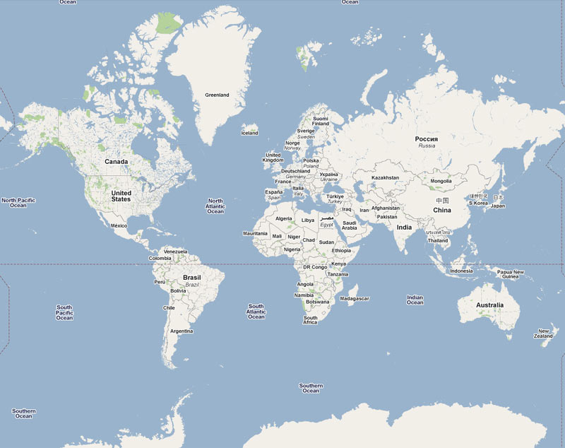
If we ask you to think about a world map then the first picture that comes to your mind is probably the map you see below:
Images from thetruesize.com
1. So why is the world map we all know «incorrect»?
Gerardus Mercator first introduced it to us in 1569 and since then it has become the most popular type of map projection. But it has lead to some serious misconceptions, because the Mercator projection distorts the size of countries as the latitude increases from the Equator to the poles. Making landmasses near the North and South Pole such as Greenland and Antarctica appear much larger than they actually are, relative to landmasses near the equator such as Central Africa.
Image by Jakub Nowosad
Now, don’t be mad at Mercator. It’s not entirely his fault that you’ve spent all these years thinking that Greenland is bigger than the United States or Russia is bigger than the whole continent of Africa. His projection was originally designed for European sailors, so that they could use it to navigate and get safely across oceans while following the straight lines his projection created. The guy honestly didn’t know his map projection was gonna be that popular among other people too…
2. Tell me, what are the real sizes of countries?
Now that you know the theory, it’s time to move on to examples. We have to warn you that you might be r-e-a-l-l-y surprised.
So, you totally thought that Norway is as big as Chile, right? Well, sorry to disappoint you but you have been wrong all along. Chile is twice as large as Norway. Who would’ve known that…
The “True Size” Maps Shows You the Real Size of Every Country (and Will Change Your Mental Picture of the World)
We all understand, on some level, that as adults we must go back and correct the oversimplifications we learned as schoolchildren. But for a sense of how large the scale of those quasi-truths, you must imagine the whole world: that is, you must imagine how you imagine the whole world, a mental picture probably taken straight from the map hung on the classroom wall. And the lines of that map came straight, in a sense, from the work of 16th-century cartographer Gerardus Mercator.
Though Mercator’s world-mapping method came as a revolution, it has also given generation after generation after generation very much the wrong idea about how big the world’s countries actually are. Mercator Projection, as Citymetric describes it, “re-imagines the earth as the surface of a cylinder.
When laid out flat, it’s pleasingly rectangular, and its eastern and western edges line up neatly.” But while “in reality, lines of longitude converge at the poles; on the map, they’re parallel. As a result, the closer you get to the poles, the more distorted the map becomes, and the bigger things look relative to their actual size.”
Hence the need for such re-imaginings of the world map as The True Size, “a website that lets you compare the size of any nation or US state to other land masses, by allowing you to move them around to anywhere else on the map.” Just search for any country in the box in the map’s upper-left corner, and that country’s borders will appear highlighted in color. When you click and drag those borders to another part of the world, specifically a part of the world at a different latitude, you’ll notice that the shape of the dragged country seems to deform.
But that appearance of distortion is only relative to the shapes and sizes we’ve long internalized from the Mercator map: when you move Australia up and it covers a third of Russia, or when you move the vast-looking Greenland down and it doesn’t even cover Argentina, you’re looking — perhaps for the first time — at a geographically accurate size comparison. Does that (to quote the humorless representative of the Organization of Cartographers for Social Equality in the West Wing episode cited as one inspiration for the True Size Map) blow your mind?
Explore the True Size Map here.
Related Content:
Based in Seoul, Colin Marshall writes and broadcasts on cities and culture. His projects include the book The Stateless City: a Walk through 21st-Century Los Angeles and the video series The City in Cinema. Follow him on Twitter at @colinmarshall or on Facebook.
TrueWorld Maps 4+
Compare countries real size
Emmanuel Teisaire
Designed for iPad
Screenshots
Description
Drag countries around to see their real size. You may be surprised!
Is really Greenland as big as all South America?
Because the Earth is a sphere, there is no way to show it perfectly on a flat map. So all maps are distorted.
With this simple app you will be able to compare countries and know how big they really are.
Simply search or tap and hold on the country you’d like to explore. You will then be able to move it around the map and watch it shift sizes as it gets closer to or farther from the equator.
You’ll also learn a few interesting facts about the selected place.
A great tool for teachers or kids and adults interested in geography.
Disclaimer about politics and partially recognised or disputed states:
The main purpose of this app is to have a notion of how big countries are. It’s not intending to perfectly reflect the limits nor the current political state of countries.
As such, we apologise for any political mistake that exists or that may exist in the future as territories evolve.
18 True Size Maps That Prove Maps Have Been Lying To You
Maps, by their very nature, are big fat liars. Despite what the Flat-Earthers would have you believe, the world is indeed spherical, meaning any 2-D attempt to depict it has to be a distortion. One of the worst of these distortions is the famous Mercator projection, which makes Greenland look like Africa, despite it being a whopping 14 and half times smaller.
If you’re looking for more accurate world maps, James Talmage and Damon Maneice’s The True Size Of app has you covered. By dragging the outlines of countries and continents across the Mercator projection, you get to see what it would be like if, say, Florida was as exaggerated a peninsula as Sweden and Norway, or if Canada got taken down a peg and didn’t benefit from its exaggerated, Mercator-enhanced form. The true size of Africa is perhaps the most shocking revelation: the Mercator projection dwarfs it, but it is actually large enough to contain both the United States and Australia. The slideshow below features some of the most surprising and eye-opening examples of what the app can reveal.
TrueWorld Maps 4+
Compare countries real size
Emmanuel Teisaire
Designed for iPad
Screenshots
Description
Drag countries around to see their real size. You may be surprised!
Is really Greenland as big as all South America?
Because the Earth is a sphere, there is no way to show it perfectly on a flat map. So all maps are distorted.
With this simple app you will be able to compare countries and know how big they really are.
Simply search or tap and hold on the country you’d like to explore. You will then be able to move it around the map and watch it shift sizes as it gets closer to or farther from the equator.
You’ll also learn a few interesting facts about the selected place.
A great tool for teachers or kids and adults interested in geography.
Disclaimer about politics and partially recognised or disputed states:
The main purpose of this app is to have a notion of how big countries are. It’s not intending to perfectly reflect the limits nor the current political state of countries.
As such, we apologise for any political mistake that exists or that may exist in the future as territories evolve.
Visualizing the True Size of Land Masses from Largest to Smallest
View the full resolution version of this infographic
Note: Some of the land areas depicted in this graphic by Art.Lebedev are shown in separate components (e.g. U.S. and Malaysia) or are disputed and/or occupied territories (e.g. Abkhazia, Crimea, and Taiwan).
The True Size of Land Masses from Largest to Smallest
Is Greenland the size of the entire African continent?
But looking at a map based on the Mercator projection, you would think so.
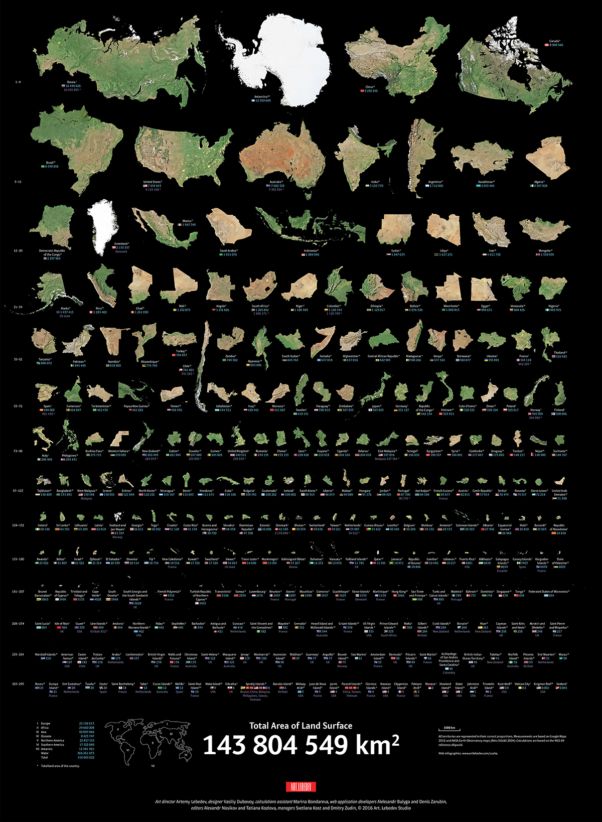
Today’s infographic comes from the design studio Art.Lebedev and shows the true size of the world’s land masses in order from largest to smallest using data from NASA and Google.
Check out the actual shape and size of each land mass without any distortions.
Distorting Reality: Mercator Misconceptions
Maps can deceive your eyes but they are still powerful tools for specific purposes. In 1569, the legendary cartographer, Gerardus Mercator, created a new map based on a cylindrical projection of sections of the Earth. These types of maps were suited for nautical navigation since every line on the sphere is a constant course, or loxodrome.
Despite the map’s nautical utility, the Mercator projection has an unwanted downside. The map type increases the sizes of land masses close to the poles (such as in North America, Europe, or North Asia) as a side effect. As a result, Canada and Russia appear to take up approximately 25% of the Earth’s surface, when in reality these nations only occupy 5%.
“Things are not always what they seem; the first appearance deceives many.” – Phaedrus
This collection of images above represents the world’s land masses in their correct proportions. Measurements are based on Google Maps 2016 and NASA Earth Observatory maps, with calculations based on the WGS84 reference ellipsoid, or more simply, a specific model of the Earth’s shape in two dimensions.
We take for granted Google Maps and satellite imaging. Making these accurate representations is no small task – the designers went through six steps and many different iterations of the graphic.
Countries are arranged by descending size and shown without external or dependent territories. For example, the total area for the contiguous United States shown does not include Hawaii, Alaska, or overseas territories.
Top 10 Largest Land Masses
Although Mercator maps distort the size of land masses in the Northern Hemisphere, many of these countries still cover massive territories.
| Jurisdiction | Area (km²) |
|---|---|
| Russia | 16,440,626 |
| Antarctica | 12,269,609 |
| China | 9,258,246 |
| Canada | 8,908,366 |
| Brazil | 8,399,858 |
| United States (contiguous) | 7,654,643 |
| Australia | 7,602,329 |
| India | 3,103,770 |
| Argentina | 2,712,060 |
| Kazakhstan | 2,653,464 |
The top 10 land masses by size account for 55% of the Earth’s total land. The remainder is split by the world’s 195 or so other countries.
Top 10 Smallest Land Masses
Here are the 10 tiniest jurisdictions highlighted on the map:
| Jurisdiction | Area (km²) |
|---|---|
| Sealand | 0.001 |
| Kingman Reef | 0.002 |
| Vatican City | 0.5 |
| Kure Atoll | 0.9 |
| Tromelin Island | 1 |
| Johnston Atoll | 1 |
| Baker Island | 1 |
| Howland Island | 2 |
| Monaco | 2 |
| Palmyra Atoll | 3 |
While the Earth’s land surface has been claimed by many authorities, the actual impact of human activity is less than one would think.
Human Impact: Humbled by Nature
Political borders have claimed virtually every piece of land available. Despite this, only 20% of land on the planet has been visibly impacted by human activity, and only 15% of Earth’s land surface is formally under protection.
The remaining 80% of the land hosts natural ecosystems that help to purify air and water, recycle nutrients, enhance soil fertility, pollinate plants, and break down waste products. The value of maintaining these services to the human economy is worth trillions of U.S. dollars each year.
While some nations are not as big as they look on the map, every piece of land counts.
The 44 Closest Stars and How They Compare to our Sun
When Will Life Return to Normal?
You may also like
How Much Land does the U.S. Military Control in Each State?
Ranked: The 20 Countries With the Fastest Declining Populations
Mapped: Corruption in Countries Around the World
Mapped: The Most Common Illicit Drugs in the World
The Problem With Our Maps
Animation: How the European Map Has Changed Over 2,400 Years
Politics
Comparing U.S. Federal Spending with Revenue
Comparing U.S. Federal Spending with Revenue
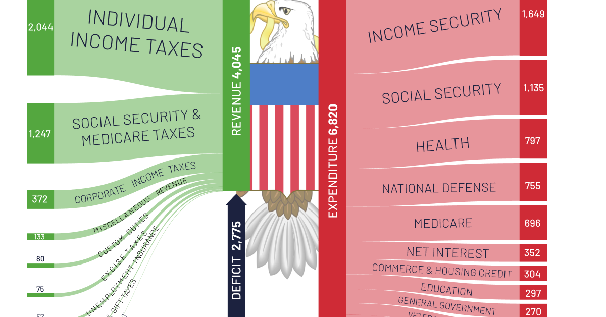
In 2021, the U.S. government spent $6.8 trillion on various expenditures and government-aided programs. Where was this money spent, and how much was covered by taxpayers’ dollars?
This graphic by Truman Du shows a breakdown of U.S. federal spending in 2021, as well as a breakdown of where the money came from, using data from USAspending.gov.
Money Comes and Goes
Here’s a full breakdown of revenue sources in 2021:
| U.S. Government Revenue Source | 2021 Amount ($B) |
|---|---|
| Individual income taxes | $2,044 |
| Social security and medicare taxes | $1,247 |
| Corporate income taxes | $372 |
| Miscellaneous revenue | $133 |
| Custom duties | $80 |
| Excise taxes | $75 |
| Unemployment insurance | $57 |
| Estate and gift taxes | $27 |
| Other retirement | $10 |
| Total | $4,045 |
Despite the trillions in revenue generated, like most years, U.S. federal spending was higher in 2021, which put the federal government in a budget deficit of $2.7 trillion.
After income and Social Security spending, health was the third-largest expenditure in 2021. Here’s a look at the full breakdown, and where spending was allocated last year:
| U.S. Government Spending Category | 2021 Amount ($B) |
|---|---|
| Income security | $1,649 |
| Social security | $1,135 |
| Health | $797 |
| National defense | $755 |
| Medicare | $697 |
| Net interest | $352 |
| Commerce and housing credit | $304 |
| Education | $297 |
| General government | $270 |
| Veterans benefits | $234 |
| Transportation | $155 |
| Administration of Justice | $72 |
| Agriculture | $50 |
| International affairs | $47 |
| Community and regional development | $47 |
| Natural resources | $42 |
| General science, space and technology | $36 |
| Energy | $6 |
| Offsetting revenue collected but not attributed to functions | ($124) |
| Total | $6,820 |
U.S. National Debt
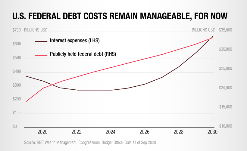
While overall debt is rising, the cost of servicing this debt has actually dropped in recent years thanks to record low interest rates.
However, with interest rates on the rise again this year, servicing the existing national debt is becoming more expensive.
And eventually, when it comes time for the U.S. government to refinance its loans, a greater portion of the federal budget will need to be allocated to servicing debt, which will put a squeeze on other areas of spending.
Politics
Ranked: Top 10 Countries by Military Spending
As geopolitical tensions began to heat up around the world, which nations were the top military spenders in 2021?
The Top 10 Countries by Military Spending in 2021
As Russia’s invasion of Ukraine has continued, military spending and technology has come under the spotlight as the world tracked Western arms shipments and watched how HIMAR rocket launchers and other weaponry affected the conflict.
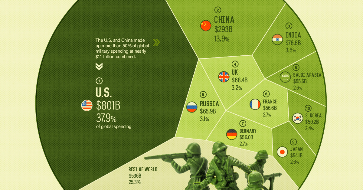
But developing, exporting, and deploying military personnel and weaponry costs nations hundreds of billions every year. In 2021, global military spending reached $2.1 trillion, rising for its seventh year in a row.
Using data from the Stockholm International Peace Research Institute (SIPRI), this visualization shows which countries spent the most on their military in 2021, along with their overall share of global military spending.
Which Countries Spend the Most on Military?
The United States was the top nation in terms of military expenditure, spending $801 billion to make up almost 38% of global military spending in 2021. America has been the top military spending nation since SIPRI began tracking in 1949, making up more than 30% of the world’s military spending for the last two decades.
| Country | Military Spending (2017) | Military Spending (2018) | Military Spending (2019) | Military Spending (2020) | Military Spending (2021) |
|---|---|---|---|---|---|
| 🇺🇸 U.S. | $646.8B | $682.5B | $734.3B | $778.4B | $800.7B |
| 🇨🇳 China | $210.4B | $232.5B | $240.3B | $258.0B | $293.4B |
| 🇮🇳 India | $64.6B | $66.3B | $71.5B | $72.9B | $76.6B |
| 🇬🇧 United Kingdom | $51.6B | $55.7B | $56.9B | $60.7B | $68.4B |
| 🇷🇺 Russia | $66.9B | $61.6B | $65.2B | $61.7B | $65.9B |
The next top military spender in 2021 was China, which spent $293.4 billion and made up nearly 14% of global military spend. While China’s expenditure is still less than half of America’s, the country has increased its military spending for 27 years in a row.
In fact, China has the largest total of active military personnel, and the country’s military spending has more than doubled over the last decade.
While Russia was only the fifth top nation by military spending at $65.9 billion in 2021, it was among the higher ranking nations in terms of military spending as a share of GDP. Russia military expenditures amounted to 4.1% of its GDP, and among the top 10 spending nations, was only beaten by Saudi Arabia whose spending was 6.6% of its GDP.
Military Collaboration Since the Russia-Ukraine Conflict
Similarly, Russia and China have deepened their relationship, sharing military intelligence and technology along with beginning joint military exercises at the end of August, alongside other nations like India, Belarus, Mongolia, and Tajikistan.
Since China’s breakthrough in hypersonic missile flight a year ago, Russia has now been testing its own versions of the technology, with Putin mentioning Russia’s readiness to export weaponry he described as, “years, or maybe even decades ahead of their foreign counterparts”.
Sanctions and Energy Exports: New Weapons in Modern Warfare
Along with advanced weaponry, sanctions and energy commodities have become new tools of modern cold warfare. As Western economic sanctions attempted to cripple Russia’s economy following its invasion, Russian gas and oil supplies have been limited and forced to be paid in rubles in retaliation.
Global trade has been turned into a new battlefield with offshore assets and import dependencies as the attack vectors. Along with these, cyberattacks and cybersecurity are an increasingly complex, obscure, and important part of national military and security.
Whether or not Russia’s invasion of Ukraine ends in 2022, the rise in geopolitical tensions and conflict this year will almost certainly result in a global increase in military spending.
TrueWorld Maps Ratings and Reviews
Great Escape!
I can get lost in this APP for hours (I have always been enamored with Maps in General) However this incredible device gives you the ability to compare and contrast the Actual dimensions that are astonishing; as well as, interesting! For instance I have worked/traveled in Italy for 25 years and Never realized that it’s width is comparable to Florida (Where I attended undergrad) also…I found it astonishing to see how similar the Continental US is the Australia (Yes, I’m a nerd; nevertheless, with this APP I feel more like a “Kool Nerd”!
Has been helpful though needs some work
Used several times as I was putting up a world wall map, with many pieces, like a puzzle, as it was better at showing the correct orientation and geographic location for the separate pieces than the illustration provided by the map maker. However several countries and islands (well known) failed to appear in the SEARCH feature. Had to manually scan/zoom in/out in the general area to find the item. Would have liked to have Option for a grid overlay & distance calculator features. But otherwise: intuitive, fast, and accurate.
Way easier & more fun to use than a website.
I’ve been to a website that does this same thing but it’s much easier to use this app. It’s a great tool for seeing what the actual sizes of countries are vs how large or small they appear to be on our maps & globes. Good job. 👍🏻
Another review again very good app but
Another review again A very good app but they show all of Ellis Island and all of the liberty island a part of New Jersey so can you make the parts of well can you make a portion of Ellis Island that New York owns today and all of Liberty Island that New York owns pretty much
Great game
Personally I think this game is a great game and I can get stuck on it for so long. I had no idea how small and big these countries really are. So overall it is a great game.
Great app but..
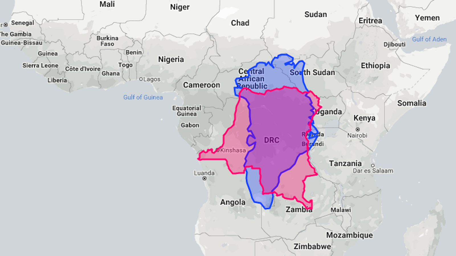
I really like this app but however, I think that more map options should be added instead of using Mercator projection all the time. I find it really inaccurate due to Greenland looking as big as Africa but in reality it’s as big as the DRC 🇨🇩. That really all I have to say in this review and I overall would love this app if it was added.
It’s a cool app maybe you can ad a feature where you can change the color of countries
Won’t work
I love this app so much, but recently I’ve been trying to open it and it won’t open it just goes to a blank screen. I love this app and I would really appreciate if that bug could be fixed. Thx
Good but can’t rotate countries
Tunis is cool. There’s a website like this, but this is cool too. The only issue is the app won’t lemme rotate the countries or change their display color like the website does. Please add these features to the app if you can. But it’s a fun idea nonetheless.
Plz make more states
I like the app an all but there’s 15 states maybe ad more like france spain Eygpt and Germany plz read this comment I really need more
TrueWorld Maps 4+
Compare countries real size
Emmanuel Teisaire
Designed for iPad
Screenshots
Description
Drag countries around to see their real size. You may be surprised!
Is really Greenland as big as all South America?
Because the Earth is a sphere, there is no way to show it perfectly on a flat map. So all maps are distorted.
With this simple app you will be able to compare countries and know how big they really are.
Simply search or tap and hold on the country you’d like to explore. You will then be able to move it around the map and watch it shift sizes as it gets closer to or farther from the equator.
You’ll also learn a few interesting facts about the selected place.
A great tool for teachers or kids and adults interested in geography.
Disclaimer about politics and partially recognised or disputed states:
The main purpose of this app is to have a notion of how big countries are. It’s not intending to perfectly reflect the limits nor the current political state of countries.
As such, we apologise for any political mistake that exists or that may exist in the future as territories evolve.
32 Muscle Ups Guinness World Record MAX TRUE
03:01 3.97 MB 641.8K
Would You Trust Sarah Boone
49:05 64.60 MB 33.8K
Nietzsche And The True World
14:23 18.93 MB 317.5K
Golden Word True Lines True World Best Whatsapp Status Whatsapp Status Video Emotional Status
28 628.91 KB 1.4K
DJ BoBo Let The Dream Come True World In Motion
06:00 7.90 MB 40.5M
ИГРАЮ В True World карта
24:07 31.74 MB 87
Madeintyo True S World
02:37 3.44 MB 332.5K
URUGUAY ON PARAGUAY TRUE WORLD MAPS
15 336.91 KB 5.4K
The Truth About The World
05:08 6.76 MB 99.7K
How The World Map Looks Wildly Different Than You Think
06:20 8.34 MB 23.9M
True World Battle Of The Godz Official Video
03:15 4.28 MB 3.2K
A UFO The Pentagon And A 3 Year Mission To Save The World The True Story Of Valiant Thor
18:28 24.30 MB 322.4K
The Dokis Come To The Real World DEMO DDLC True World MOD
28:56 38.08 MB 6.7K
Marc Márquez A True World Champion Highlights 125cc Moto2 MotoGP
03:37 4.76 MB 49.3K
как получить любой штат в True World карты
37 831.05 KB 102
Nietzsche How The True World Finally Became A Fable
17:02 22.42 MB 1.8K
The World S Hidden Truth YOU WON T BELIEVE WHAT THEY ARE DOING HIDDEN TRUTH
07:56 10.44 MB 1M
Can LANKYBOX Beat The TRUE INGREDIENTS EVIL SPONGEBOB ATTACKED US
22:03 29.02 MB 122.9K
ROMANIA ON POLAND TRUE WORLD MAPS
True World Dreamy
02:26 3.20 MB 4.5K
True World Sandeep Maheshwari Describe My Channel
20 449.22 KB 824
True World OSTAVITSLED Worldview Phonk
01:57 2.57 MB 216
TRUE WORLD OF PIGGY JUMPSCARES
35:18 46.46 MB 13.2M
Sabagebu IT S A TRUE WORLD
01:09 1.51 MB 89.2K
कभ कभ अपन स ब छड न पड त ह True World Motivatonal WhatsApp Status Sad Emotional
TRUE WORLD OF PIGGY JUMPSCARES 2
26:35 34.99 MB 832.5K
Iron Throne TRUE WORLD Capital Battle MASSIVE Rallies Clashing
06:22 8.38 MB 2.3K
The WORST PARENTS EVER Go To COURT
57:02 75.06 MB 281.5K
True World Memory
02:03 2.70 MB 783
Anarchadia Feat Jon Schaffer True World Order Wmv
03:42 4.87 MB 4.3K
12 Largest Countries In True World Maps
20 449.22 KB 2.7K
True World MDShohag
15 336.91 KB 461
প ত ন র ক ছ য ক রণ হ র য চ ছ জ ল নস ক True World
03:29 4.58 MB 18.2K
True World Foods Expo 2022 Introduction
30 673.83 KB 617
NEW TRUE WORLD OF PIGGY JUMPSCARES
25:56 34.13 MB 47.2K
The Lie We Live
08:25 11.08 MB 13M
JUNIOR REID TRUE WORLD ORDER 1997
01:12:49 95.83 MB 13.6K
Sadie True World English Subs
04:59 6.56 MB 5.7K
How The True World Ultimately Became A Fable The History Of An Error Nietzsche
03:53 5.11 MB 2.7K
True World Emraan Hashmi Motivation Status Motivation Line
05 112.30 KB 2.3K
True World Order Skit
03:06 4.08 MB 8.8K
HUMANKIND FULL TRUE EARTH MAP GAMEPLAY MAX DIFFICULTY
03:53:46 307.65 MB 60.9K
D Shot Too Short Spice 1 True Worldwide Playaz
06:30 8.55 MB 54.8K
Sachin Tendulakar Ko Bhi Love Huaa Tha Motivational Status True World Status True Line
30 673.83 KB 2.3K
True World Fantastic Life ClassicsatishChoudhary
New Order True Faith 1987 Official Music Video HD REMASTERED
04:20 5.70 MB 24.2M
True World Original Mix
03:24 4.47 MB 241
Pray For The True World パチスロ 戦律のストラタス サウンド試聴
01:48 2.37 MB 45.5K
Why All World Maps Are Wrong
06:00 7.90 MB 21.1M
Для вашего поискового запроса True World мы нашли 50 песен, соответствующие вашему запросу. Теперь мы рекомендуем загрузить первый результат 32 Muscle Ups Guinness World Record MAX TRUE который загружен Max True размером 3.97 MB, длительностью 3 мин и 1 сек и битрейтом 192 Kbps.
Слушают сейчас
Crap Rappers Original Mix
Халық Әні Жариям Айдай Айбол Құдайбергенов Фэа Сазген
Сборник Танцевальных Песен Для Гулянки
Dance Monkey Remix
Память Посвящается Юра Шатунов
Клип Королева Зла
Drift Honda Hr V
Dirrt Remix Tiktok
خبز القمح الكامل بالنخالة و الشوفان ياغورت النخالة البركة في القليل صليحة بسكري Samira Tv
Undertale Not Musical Genocide Mettaton
Ислам Итляшев А Он Тебя Оставил Навсегда
Ламиноу Ламиноу Песня
Зиверт На Трубке Занято
Играем В Доктора Мама Заболела Дамик Лечит Маму
Мубориз Усмонов Ва Мадина Акназарова Дуст Надори Muboriz Ft Madina Dust Nadori 2020
Osman Poison Original Mix
Zohid Jony Это Любовь Свела Меня С Ума Dndm Remix
Френ Боу Edit Френ Боу За 1 Минуту 34 Секунды
The Hot Damns Something Evil Ft Marc Scibilia
День Знаний Автор Оксана Панькова Исполняет Анна Горская
Stray Kids Charmer Clean Instrumental
Ана Москва Мына Москва
Аниме Клип Amv Я Видел Страх В Чужих Глазах Нагиса
Esh Moonlight Tiktok Ver Hd Music
Шохимардон Алимардон Тагаевлар Пролетар Концертдан Парча
Новинки Шансона Летний Дождь Владимир Песня
Ruslan Bakinskiy Bomba Bomba2019
Отам Уйнасин Онам Уйнасин
Izzat Shukurov Aisha Humaira Official Music Video
TrueWorld Maps 4+
Compare countries real size
Emmanuel Teisaire
Designed for iPad
Screenshots
Description
Drag countries around to see their real size. You may be surprised!
Is really Greenland as big as all South America?
Because the Earth is a sphere, there is no way to show it perfectly on a flat map. So all maps are distorted.
With this simple app you will be able to compare countries and know how big they really are.
Simply search or tap and hold on the country you’d like to explore. You will then be able to move it around the map and watch it shift sizes as it gets closer to or farther from the equator.
You’ll also learn a few interesting facts about the selected place.
A great tool for teachers or kids and adults interested in geography.
Disclaimer about politics and partially recognised or disputed states:
The main purpose of this app is to have a notion of how big countries are. It’s not intending to perfectly reflect the limits nor the current political state of countries.
As such, we apologise for any political mistake that exists or that may exist in the future as territories evolve.
This animated map shows the true size of each country
Everything is relative.
The Mercator Map Projection with the true size and shape of the country overlaid.
Credit: Neil Kaye/@neilrkaye
This animated map shows the true size of each country
Everything is relative.
The Mercator Map Projection with the true size and shape of the country overlaid.
One of the best known and commonly used world maps, the Mercator Projection, depicts Greenland and Africa as being roughly the same size. In reality, Africa is 14 times larger.
Suddenly, we see countries like the United States, Canada and Russia shrink (and separate, so that seas appear where there are none), while the giant landmasses of Africa and South America remain more or less the same.
Australia, which is the planet’s sixth largest country by size after Russia, Canada, China, the US and Brazil, also remains consistent across the animation.
Originally designed to be a navigator’s tool, the Mercator Map Projection has for centuries been a mariner’s best friend, because it represents lines of constant true direction, which means a straight line connecting any two points on the map will travel in the same direction that a compass would show.
The way it’s designed means that objects closer to the equator appear in relative scale to one another, but objects closer to the poles appear larger than they are.
In the 1980s, it became widely used in classrooms to teach geography, and until 2018, was Google’s choice of map projection.
In recent years, much has been made of the distortion it applies to relative country landmass size, but Kaye’s animation drives the point that it was designed for nautical purposes rather than as an educational resource.
Showing the Mercator Map Projection with the true size and shape of the country overlaid#dataviz #maps #gis #mapping pic.twitter.com/Gqr1Dd8YrM
As Nick Stockton points out at Wired, “It’s really not a bad map. It’s just been in the wrong place for a long time.”
TrueWorld Maps 4+
Compare countries real size
Emmanuel Teisaire
Designed for iPad
Screenshots
Description
Drag countries around to see their real size. You may be surprised!
Is really Greenland as big as all South America?
Because the Earth is a sphere, there is no way to show it perfectly on a flat map. So all maps are distorted.
With this simple app you will be able to compare countries and know how big they really are.
Simply search or tap and hold on the country you’d like to explore. You will then be able to move it around the map and watch it shift sizes as it gets closer to or farther from the equator.
You’ll also learn a few interesting facts about the selected place.
A great tool for teachers or kids and adults interested in geography.
Disclaimer about politics and partially recognised or disputed states:
The main purpose of this app is to have a notion of how big countries are. It’s not intending to perfectly reflect the limits nor the current political state of countries.
As such, we apologise for any political mistake that exists or that may exist in the future as territories evolve.
Посмотрите на реальные размеры стран с помощью сервиса
Для отображения поверхности Земли на плоскости используется картографическая проекция, однако в любой проекции существуют искажения. Суть этой проекции заключается в том, что фигуру небесного тела, которая не разворачивается в плоскость, заменяют на другую фигуру, развёртываемую на плоскость. При этом на вторую фигуру наносится сетка параллелей и меридианов с эллипсоидной формы.
В наши дни широко применяется проекция Меркатора — вспомните школьный атлас или стандартную карту мира. Эта проекция имеет различный масштаб на разных участках, и если основной масштаб относится к экватору, то наибольшие искажения размеров материков и других объектов будут у полюсов.
Например, страны, находящиеся на экваторе, имеют наиболее точный масштаб. Но чем дальше от экватора, тем искажения размеров будут больше. Возьмём Гренландию: на карте этот материк выглядит больше Австралии и по размерам сопоставим с Южной Америкой. Но если быть точным, Гренландия втрое меньше Австралии и в 8 раз меньше Южной Америки.
TrueWorld Maps 4+
Compare countries real size
Emmanuel Teisaire
Designed for iPad
Screenshots
Description
Drag countries around to see their real size. You may be surprised!
Is really Greenland as big as all South America?
Because the Earth is a sphere, there is no way to show it perfectly on a flat map. So all maps are distorted.
With this simple app you will be able to compare countries and know how big they really are.
Simply search or tap and hold on the country you’d like to explore. You will then be able to move it around the map and watch it shift sizes as it gets closer to or farther from the equator.
You’ll also learn a few interesting facts about the selected place.
A great tool for teachers or kids and adults interested in geography.
Disclaimer about politics and partially recognised or disputed states:
The main purpose of this app is to have a notion of how big countries are. It’s not intending to perfectly reflect the limits nor the current political state of countries.
As such, we apologise for any political mistake that exists or that may exist in the future as territories evolve.
Подборка криптокарт и виртуалок, доступных россиянам
После ухода Visa и MC из РФ, появилось много проблем с платежками: нечем платить в сторах и иностранных шопах, не оформить платную подписку на любимый сервис, не получается платить с телефона через Google и Apple Pay. Сервисы аренды карт, которые вышли в паблик после февраля 2022, в основном закрывают только одну из проблем — они позволяют оплачивать рекламу. В сегодняшней подборке мы собрали платежки под любые цели и задачи.
Vexel доступен гражданам РФ, подходит как для оплаты в магазинах, так и для хранения крипты и фиата. Также сервис выдает займы в крипте, но необходимо оставить залог.
Чтобы получить карту Vexel необходимо:
После выпуска карт, пользователям открывается доступ к криптовалютному и фиатному счетам. Криптокарты пополняются с помощью внутреннего кошелька Vexel. После пополнения средства автоматом конвертируются в евро.
Сначала нужно пройти верификацию с помощью загранпаспорта, после чего будет доступен выпуск/перевыпуск MasterCard и мультивалютный счет. Виртуалки можно пополнять с помощью криптокошелька через Binance Pay, с нероссийских карт и ваучером.
Карты выпускаются Sutton Bank. Одна виртуалка живет 60 дней с момента создания. В США есть ограниченияпо доступности.
Для получения дебетовой карты регистрируемся с использованием генераторов фейковых личностей. Тип бизнеса выбираем «Индивидуальный», данные компании берем с Google-карт. Верификация по документам не требуется.
С февраля в паблик было слито много сервисов, где можно без иностранного гражданства получить хотя бы одну виртуальную карту. Первым в ход пошел нашумевший в ТГ-чатах — OZAN. Для выпуска карты приложение требовало только загранник (даже РФ) и любую симку. В начале июня OZAN перестал верифицировать российских пользователей. Сейчас, хоть на сервисе и слабый антифрод, получить карты удается единицам.
TrueWorld Maps 4+
Compare countries real size
Emmanuel Teisaire
Designed for iPad
Screenshots
Description
Drag countries around to see their real size. You may be surprised!
Is really Greenland as big as all South America?
Because the Earth is a sphere, there is no way to show it perfectly on a flat map. So all maps are distorted.
With this simple app you will be able to compare countries and know how big they really are.
Simply search or tap and hold on the country you’d like to explore. You will then be able to move it around the map and watch it shift sizes as it gets closer to or farther from the equator.
You’ll also learn a few interesting facts about the selected place.
A great tool for teachers or kids and adults interested in geography.
Disclaimer about politics and partially recognised or disputed states:
The main purpose of this app is to have a notion of how big countries are. It’s not intending to perfectly reflect the limits nor the current political state of countries.
As such, we apologise for any political mistake that exists or that may exist in the future as territories evolve.
How big are Earth’s countries, really?
If you want to know the true size of the world, don’t look at an atlas.
This may sound like a conspiracy theory but our current world map is wrong. The size and shape of countries and continents are either much bigger or much smaller than you think.
Why is this? It all comes down to maths.
The Earth is a sphere, a 3D shape. Maps are flat and 2D. If you try and translate one to the other you will always create alterations trying to make it fit.
It helps to think of the Earth as an orange. If you were to draw the continents on the skin, peel it and lay it flat you will notice that however many ways you try, some part of the map will always become distorted. It is this problem that effects almost every world map that we see, meaning few of us have a realistic idea about the size of our countries.
Africa for example, is a lot bigger than we think. The Mercator Projection map suggests that the USA is half the size of Africa, when it’s less than one-third. Germany and Tanzania appear the same size, but Tanzania is in fact over 200,000 square miles bigger. Unless two countries are parallel to one another, one will always be bigger or smaller than we think.
If this is boggling your mind, there is an alternative. The Flat Earth Society hold the belief that we are in fact living on a floating disc – certainly one way to address the world map problem! For those however with a more scientific head, our new infographic will dispel any myths and reveal the true size of our world by overlaying the Galls-Peters Projection of countries on top of one another.
Embed this true size of countries infographic on your site:
Animated Maps Reveal the True Size of Countries (and Show How Traditional Maps Distort Our World)
The world maps we know all misrepresent the world itself: we’ve all heard it many times before, but how well do we understand the nature of that misrepresentation? “For many people, the Earth as they know it is heavily informed by the Mercator projection – a tool used for nautical navigation that eventually became the world’s most widely recognized map,” writes Visual Capitalist’s Nick Routley. But the Mercator projection dates to 1569, and “the vast majority of us aren’t using paper maps to chart our course across the ocean anymore, so critics of the Mercator projection argue that the continued use of this style of map gives users a warped sense of the true size of countries.”
Some of the geographical misconceptions Gerardus Mercator inadvertently instilled in humanity to this day include exaggerations of the size of Europe and North America. “Visually speaking, Canada and Russia appear to take up approximately 25% of the Earth’s surface” on a Mercator map, “when in reality they occupy a mere 5%.”
Figures are one thing, but a fair few 21st century cartography enthusiasts have also used technology unavailable and indeed unimaginable in Mercator’s day to show us in a more immediately legible way exactly how his projection distorts land masses. Recently, a climate data scientist named Neil Kaye has used the form of the animated GIF to show what happens when countries shrink to their actual size on a Mercator map, and when Mexico and Greenland trade places.
As soon as Mexico goes north and Greenland goes south, it becomes obvious that both are really of a similar size, though we might have assumed the latter to be much larger than the former. And in fact, Mercator projection makes all countries farther from the equator look larger in relation to all countries nearer to the equator. We’ve pointed out the impossibility of making a perfectly faithful two-dimensional world map before here before on Open Culture, an impossibility that hasn’t stopped cartographers from trying to come up with more and more accurate projections. But even they can’t substitute for an acute awareness of how even the most popular maps can be wrong, an awareness you can develop even more intensively by viewing the many other cartographic creations Kaye has posted to the “Map Porn” subreddit — another technological development Mercator surely couldn’t have foreseen.
Related Content:
Based in Seoul, Colin Marshall writes and broadcasts on cities, language, and culture. His projects include the book The Stateless City: a Walk through 21st-Century Los Angeles and the video series The City in Cinema. Follow him on Twitter at @colinmarshall or on Facebook.
TrueWorld Maps 4+
Compare countries real size
Emmanuel Teisaire
Designed for iPad
Screenshots
Description
Drag countries around to see their real size. You may be surprised!
Is really Greenland as big as all South America?
Because the Earth is a sphere, there is no way to show it perfectly on a flat map. So all maps are distorted.
With this simple app you will be able to compare countries and know how big they really are.
Simply search or tap and hold on the country you’d like to explore. You will then be able to move it around the map and watch it shift sizes as it gets closer to or farther from the equator.
You’ll also learn a few interesting facts about the selected place.
A great tool for teachers or kids and adults interested in geography.
Disclaimer about politics and partially recognised or disputed states:
The main purpose of this app is to have a notion of how big countries are. It’s not intending to perfectly reflect the limits nor the current political state of countries.
As such, we apologise for any political mistake that exists or that may exist in the future as territories evolve.
Comparing the True Size of Every Country
Share this article


Most representations of the world do not accurately project their true size, this visualization does. The Mercator projection is a cylindrical projection of the world that was created for nautical navigation. This projection, while the most common projection, has a large flaw–it distorts the size of most countries.
The largest problem with projecting a 3D object in 2D is that some dimensions will always get distorted. Throughout the history of map-making cartographers have struggled with how best to project the world most accurately. In fact, in 2018 Google Maps changed to a more accurate ‘globe’ projection, moving away from the Mercator projection.

Take a look at these cool websites if you like checking out maps:
TrueWorld Maps 4+
Compare countries real size
Emmanuel Teisaire
Designed for iPad
Screenshots
Description
Drag countries around to see their real size. You may be surprised!
Is really Greenland as big as all South America?
Because the Earth is a sphere, there is no way to show it perfectly on a flat map. So all maps are distorted.
With this simple app you will be able to compare countries and know how big they really are.
Simply search or tap and hold on the country you’d like to explore. You will then be able to move it around the map and watch it shift sizes as it gets closer to or farther from the equator.
You’ll also learn a few interesting facts about the selected place.
A great tool for teachers or kids and adults interested in geography.
Disclaimer about politics and partially recognised or disputed states:
The main purpose of this app is to have a notion of how big countries are. It’s not intending to perfectly reflect the limits nor the current political state of countries.
As such, we apologise for any political mistake that exists or that may exist in the future as territories evolve.
Реалистичный пазл мира True World Puzzle Black
Код производителя: 6803
Тип товара: Подарок мужчине
ID: 1353447
Описание
В набор входит:
6 пакетов со странами (по континетам);
Формы для сборки 6 континентов (20 частей);
Cтикеры для проклейки форм (25 шт);
Яркие метки для стран (30 шт);
Монтажная пленка для приклейки карты (2шт);
Ракель для приклейки пленки;
Инструкция и список стран.
Видео обзоры (3)
РЕАЛИСТИЧНЫЙ ПАЗЛ МИРА TRUE WORLD PUZZLE BLACK
World Map True Puzzle Реалистичная карта мира в виде пазла
42,000 piece jigsaw puzzle timelapse
Стирающаяся карта открытий
Цены на Яндекс.Маркет
Цены (1)
Как купить или где мы находимся +
«СкидкаГИД» — это сервис сравнения цен в магазинах, кэшбэк сервис и помощь в выборе товаров, посредством подборки видео обзоров, отзывов и сравнения товаров. Большинство магазинов, представленных на сайте, осуществляют доставку по России, поэтому выгодно пользоваться онлайн заказом на сайте этого магазина (доставляются ли заказы в ваш регион, можно узнать на сайте выбраного магазина). Чтобы купить выбранный товар, необходимо кликнуть кнопку «купить» на против выбранного магазина и продолжить покупку на сайте этого магазина. Чтобы получить кэшбэк выполните теже действия предварительно зарегистрировавшись.
Реалистичный пазл мира True World Puzzle Black
Последняя известная цена от 3990 руб до 3990 руб в 1 магазинах
AliExpress – один из крупнейших мировых маркетплейсов,
предлагающий клиентам самые низкие цены
Кэшбэк в AliExpress до 43.6%
Кэшбэк сервис СкидкаГИД
Купить в соседних городах
Сервисы для г.Москва
Инновационный нанопоиск авиабилетов найдет для вас не только самый лучший вариант на конкретные даты, но и предложит другие даты, когда стоимость перелета может быть ещё ниже. Выбирайте самые «дешёвые даты» в специальном разделе сайта Цены на авиабилеты
подобрать билет или отель
Выбирайте из более чем 3 000 000 гостиниц, санаториев, турбаз, хостелов и апарт-отелей. Собираем в одном месте все доступные варианты номеров, которые предлагают агрегаторы и владельцы отелей. Сравните цены и условия и выберите, где бронировать выгоднее.
«Утконос» – лидер в области интернет-торговли продуктами питания и сопутствующими товарами.
Электронный полис ОСАГО (е-ОСАГО) – это тот же полис ОСАГО, только в виде электронного документа и имеет ту же юридическую силу с подписью и печатью от страховой компании. По закону электронный полис необязательно распечатывать и достаточно иметь под рукой в смартфоне.
Бесплатная первая доставка. Быстрая доставка от 30 минут.
Купить в кредит (3)
получить заём
Короткие займы Joymoney (основной продукт):
получить заём
— займ на карту или счет;
— перевод на любую банковскую карточку, выпущенную любым банком в России;
— перевод на ваш личный банковский счёт в любом банке России;
— денежный перевод через систему CONTACT.
Как создать правдоподобную карту для фэнтези-мира
Советы и инструменты, которые помогут вам создавать игровые карты для вымышленных миров.
Какие аспекты игрового мира сделают его более правдоподобным? На этот и другие вопросы отвечает Нэйтан Вандерзи с Youtube-канала WASD20.
Примечание: эти советы не являются обязательными для каждой карты. Ваш игровой мир мог быть создан древней магией и драконами, столкнувшимися в воздухе. Вас не будут обвинять в том, что вы не придумываете правдоподобные биомы в мире, где трава растет вверх ногами, а на небе 3 луны. Но если вы стремитесь создать реалистичный мир, то эти советы и заметки могут вам помочь.
Реки не разделяются по мере своего течения. Если вы видите на карте речную «вилку», то это реки, напротив, объединяются в один большой поток. Помните, что реки текут из более высокой точки в самую низкую из возможных для них.
Есть некоторые исключения из этого правила про разделение, например, дельта Нила. Но они очень редки и зависят от сезона, и Нэйтан советует в целом не разделять реки, а сливать их вместе.
Как правило, у озер есть только одна река, которая вытекает из них и впадает в другое озеро, море или океан. Это происходит потому, что реки выбирают путь наименьшего сопротивления и протекают через самую низшую точку-выход из озера. Крайне маловероятно, что у озера будет два одинаково низких пути выхода.
Есть случаи, когда у озера вообще нет вытекающих из него рек — как у Каспийского моря, которое можно считать самым большим бессточным озером. Оно осушается только за счет испарения.
И еще раз: реки текут от самых высоких до самых низких точек. Если вы в начале и конце реки «поставите» берега, это просто сделает ее морем. Лучше разместить исток вашей реки где-нибудь в горах, потому что в реальном мире они обычно начинаются именно там. И помните, когда вы создаете речной путь — вы определяете низкие точки земли.
Обычно горы появляются благодаря факторам, которые, как правило, создают множество гор, а не только одну. Будь то тектонические плиты или вулканическая активность, они скорее приведут к появлению горного хребта. Даже Одинокая Гора в Средиземье на самом деле не так уж одинока: рядом находятся Серые горы, Горы Лихолесья и Железные холмы.
В целом это зависит от того, о какой степени одиночества мы тут говорим. Технически что-то вроде Одинокой горы возможно в реальной жизни, и скорее всего причиной будет вулканическая активность, которая создает горы более «случайным» образом. Например, в реальном мире вулкан Килиманджаро может выглядеть довольно одиноким при некоторых ракурсах:
Однако на других фотографиях мы видим, что у него есть друзья неподалеку:
Тоже вулканы, как видно на этой карте:
Есть что-то романтичное в идее совершенно одинокой горы посреди бесконечного плоского поля, и для этого могут быть какие-то магические причины в вашем мире. Однако если вы стремитесь к большей реалистичности и правдоподобию, постарайтесь создавать горы группами.
У множества гор на Земле одна сторона — густо поросшая и часто поливается дождями, а другая — довольно засушливая. Это связано с господствующими ветрами, которые дуют с одной стороны гор: поднимаясь к вершинам, влажные воздушные массы остывают и проливаются дождем. Таким образом ко второй стороне горы ветра добираются уже «сухими». Хороший пример из реального мира — Тибетское плато:
Господствующие ветра обычно дуют с моря (за редким исключением), имейте в виду этот географический нюанс.
Если вы рисуете карту не для одного отдельного региона, а хотите охватить всю поверхность планеты (то есть практически создать глобус), подумайте о том, как раньше массивы суши сочетались друг с другом, особенно, если ваш мир достаточно стар.
Континенты Земли много миллионов лет назад тоже были объединены в один сверхконтинент — Пангею. По форме современных континентов вы все еще можете увидеть следы того, что раньше они были вместе.
Здесь вам может помочь сайт Tectonics.js — 3D-симулятор движения тектонических плит.
Чтобы знать, где располагать горные хребты, нужно понимать, как они возникают. Обычно горы идут с севера на юг: вдоль линий столкновения крупнейших тектонических плит Земли. А еще они образуются вдоль побережий. Например, Анды сформировались вследствие и вулканической активности, и субдукции.
Субдукция — это когда одна литосферная плита погружается под другую. Две плиты сталкиваются, и горы образуются на той, которая наползает сверху. Именно так образовались самые большие горы на Земле: когда Индия, раньше бывшая частью Африки, откололась и врезалась в Евразию.
Еще горы довольно часто формируются благодаря вулканической активности. Там, где земная кора тонкая, магма и расплавленная порода пробиваются наружу. Образуются горы, вулканы и острова: так появились Гавайи. Так же появляются цепи горных островов — посредством вулканической активности.
Вода традиционно была и есть важной частью человеческой жизни. Создавая поселения, вы должны думать об источниках воды поблизости и о том, где именно будет выгодно разместиться вашим народам: например, очень важны места с достаточным количеством воды для сельского хозяйства, или те, где можно расположить порт. В общем, места рядом с водоемами — отличные стартовые точки для построения цивилизации.
Нэйтан отмечает, что при этом делает исключения для гномьих поселений, которые обычно располагаются в самых скалистых горах из всех возможных, «потому что, видимо, гномы едят камни». Ну или потому, что там протекают подземные реки.
Порты обычно располагаются в местах, которые находятся не прямо на побережье, а немного в глубине суши, например, в заливе. Выберите область, которая была бы защищена от бурных вод и сильных ветров, и разместите там портовый город или населенный пункт.
Еще одна вещь, которую следует учитывать, — это глубина залива или гавани, на которой расположен ваш город. Воды должны быть достаточно глубокими, чтобы корабли могли приходить и уходить, когда им заблагорассудится, не садясь на мель.
Кроме того, порты обычно расположены в местах, которые не замерзают в течение года. Если ваш мир — ледяная пустошь, будет сложнее. Ваши люди, скорее всего, все еще построят порт где-нибудь, но если у них будет выбор, он с большой вероятностью падет на воды, которые не замерзают круглый год.
Лучше сохранить климат, подобный тому, который мы видим на Земле. Палящие пустыни не стоит располагать вблизи ледников, вы должны создать буферные зоны между ними, чтобы все было реалистично. Размеры этих буферных зон, однако, зависят от вас.
Кроме того, в климате скорее всего будет определенный ритм: как, например, то, что на полюсах — холодно, а чем ближе к экватору — тем жарче.
И прежде, чем мы перейдем к инструментам, слово напоследок — нарушайте правила! Вы уже поняли, что из многих правил есть исключения, а еще многое можно обосновать магией. Вы не обязаны четко следовать законам реального мира, если вы не хотите и если вам это не приносит удовольствия.
Генератор на основе Гудини создает карты как в классических RTS-играх (стратегиях в реальном времени). Он был вдохновлен Unity of Command, Civilization 5, Battle Worlds: Kronos и WARTILE. В генераторе можно регулировать высоту участков земли, добавлять водоемы и многое другое.
Скачать можно бесплатно.
С помощью Wonderdraft вы сможете создать карту всего мира или только одного континента, где возможно разместить горы и холмы, леса и водоемы и так далее. С помощью более тонких настроек можно создавать разные типы суши, формировать береговые линии и не только. Wonderdraft содержит готовые паки построек для создания поселений.
Это программное обеспечение для составления карт на базе искусственного интеллекта для настольных RPG. ИИ динамически заполняет комнаты, которые вы рисуете, и добавляет двери, стены, освещение, мебель и другие объекты на лету. Вы также можете настроить тему и функции комнаты, как только у вас будет базовая планировка. Существует возможность переключаться на 3D-вид.
Само приложение еще не вышло — дата релиза запланирована на 24 декабря. Следить можно на страничке проекта в Steam.
Перевод выполнен Александрой Супрун, автором в Smirnov School. Мы готовим концепт-художников, левел-артистов и 3D-моделеров для игр и анимации. Если придёте к нам на курс, не забудьте спросить о скидке для читателей с DTF.
Вот так мы и узнали, насколько внимательно Smirnov School выбирает программу курсов и кем считает своих потенциальных учеников 🙂
В самом начале и конце статьи мы отметили, что это переложение видео Нэйтана Вандерзи на текст) потому логично, что изображения и структура взяты из этого же видео!
Мы не заметили, что такой перевод уже есть, за что горячо просим прощения♡ Но мы честно сами перевели и подготовили эту статью)
Я уже знаю, как создавать карты для фентези-мира
Правило интернета номер №3746: Если есть программа или игра, предоставляющая творческую свободу, то на ней обязательно есть возможность создать или нарисовать член.
то есть он без знания географии сделал игру, не важно какую, а ты великий географ можешь только сканворды разгадывать? ну и кто тут не прав
Можно подумать во всех играх есть карта, пффффф.
Комментарий удален модератором
И не создавайте фэнтези миров?
Комментарий удален модератором
Блин, ещё раз убедился в том, насколько я географический гик после того, как узнал в «фэнтези» картах с изображением портов реальные места:
— Устье реки Колумбия в штате Орегон в США
— Полуостров Олимпия + юг острова Ванкувер
Чтобы создать реалистичный и правдоподобный фэнтези мир нужно отказаться от огромных мечей как у Гатса. И ещё надо отказаться от летающих островов и фантасмагоричных каньонов в стиле Final Fantasy потому что это неправдоподобно. Ещё надо одеть женщин в фэнтези как в средневековой европе, то есть без всяких топиков, платьев с декольте и т.д. И пусть ещё огромную роль будет играть церковь, которая диктует всем правила и сжигает колдунов и красивых женщин. Ну и вообще кому нужна магия если это нереалистично и неправдоподобно. Ай к чертям, я автор сам так решаю!
Прям таки r/worldbuilding какой-то, где люди вместо придумывания интересного сюжета изучают матан чтобы создать фэнтези-мир.
Кстати, был такой писатель Ларри Нивен, который написал серию научно-фантастических книжек про «Мир-кольцо», и сперва он написал как бы научно, инженерно и астрономично, но не слишком, на что получил море писем от всяких нердов и студентов МТИ, где те разъяснили где и как он ошибся, чего не может быть и как отдельные нестыковки можно пофиксить.
В результате, вторую книжку «Инженера Кольца» он уже написал с учетом всего того матана, что ему накидали в письмах (например, прикрутил к Кольцу двигатели-стабилизаторы), да еще добавил приложение с характеристиками выдуманного им мира:
1 день = 30 земных часов.
1 оборот = 7,5 дней.
75 дней = 10 оборотов = 1 фалан.
Масса = 2×1030 граммов = 300 масс Земли (приблизительно) = массе Юпитера (приблизительно).
Радиус = 0,95×10⁸ миль = 1,53×10⁸ км = 1 Астрономическая единица (приблизительно).
Окружность = 5,97×10⁸ миль = 9,6×10⁸ км
и так далее.
Вот это подход у человека. Дальше у него там бегают по планете всякие двуголовые тянитолкаи и каджииты, но сюжет книжки я вообще не помню.
Зато вся эта история с расчетами запомнилась.
Real Country Sizes Shown on Mercator Projection (Updated)
Hover or click on a country to see how much it shrinks from the Mercator projection size.
Check out some other engaging and interactive map dataviz:
I remember as a child thinking that Alaska was as large as 1/2 of the continental US. Later, however, I learned that while it is the largest state, it is actually only about 1/5 the size of the lower 48 states. My son has also remarked that Greenland is very big. And while it is very big, it’s nowhere near the size of the continent of Africa.
The map above shows the distortion in sizes of countries due to the mercator projection. Pressing on the button animates the country ‘shrinking’ to its actual size or ‘growing’ to the size shown on the mercator projection. It was inspired by a similar animation that I saw on reddit and decided I wanted to try to build the same thing.
The mercator projection is a commonly used projection on computer maps because it has perpendicular latitude and longitude lines (forming rectangles). It is formed by projecting the globe onto a cylinder A variant of the was adopted by Google maps, which helped establish it as the informal standard for web-based maps (although Google maps now also uses a globe view, instead of a map projection when zooming out to a very wide view).
Areas far from the equator are distorted in terms of their distances and are shown much larger than they actually are. This is one of the major issues with a projection of a globe onto a cylinder area. This is why Greenland, Russia and Canada shrink so much in height and width in the animation, they are fairly high in latitude in the Northern Hemisphere. Also important is that the closer you are to the poles, the more the distortion when a country is shown on the Mercator projection. Since longitude lines converge at the poles, but are parallel on a Mercator, the closer a part of a country is to the poles, the more that part will get stretched wider relative to a part of a country that is not as close to the poles. As a clear example, see what happens to the southern part of Australia, relative to the northern end. Similarly, the latitude lines also get further apart on a Mercator projection, while on a globe they stay equidistant. This means that the parts of countries that are nearer the poles will get taller, i.e. stretched out from a north-south perspective relative to parts of countries that are further from the poles. You can see this clearly in the northern ends of Russsia and Greenland, where the tops get smushed down.
This next graph shows each country plotted with their actual land area and apparent land area as shown on a Mercator projection. The further the countries are from the 1:1 line the greater the overestimate of their size from the Mercator (also color coded to be red). It is a logarithmic plot showing many different orders of magnitude in country size. The table also shows the top 10 countries whose size is overestimated (and the difference in land area in square kilometers or as a percentage reduction from the size in the Mercator projection).
As it shows, Greenland is the country that has the largest percent difference between its apparent size in a Mercator projection and it’s real size (it’s only about 1/4 of the apparent size). And Russia is the country with the largest absolute difference between these two sizes.
This is the original graph that keeps the shape of the countries exactly the same and just scales the size. This is incorrect because as you move towards the poles the distances between longitude lines decreases. As a result the tops (northern ends) of countries will shrink more than the bottoms (southern ends) of countries in the Northern Hemisphere and vice versa in the Southern Hemisphere.
Old map that changes sizes but incorrectly preserves the Mercator shape
Calculations:
I calculated the area in two ways, one assuming latitude and longitude are rectangular coordinates (i.e. Mercator projection) and the other was the actual area.
The new coordinates needed to draw the “real size” of the countries are derived by calculating the distance between the center of the country and each of the coordinates in the country’s shapefile. As you move towards the poles on a globe, the distance between longitude lines decreases as a function (cosine) of latitude. In a mercator projection, the longitude lines are shown as equi-distant regardless of latitude. In this calculation, we create a new set of coordinates by calculating the distance between the center of the polygon and each set of coordinates and change the coordinates to reflect the shrinking of distance between longitude lines as you head towards the poles.
In the previous version of this animation, I calculated the latitude and longitude coordinates for the outline of the “real” size by modifying the original latitude and longitude by the ratio of these two areas to draw the new smaller, “real” country size.
Data and tools: This visualization was made using the Leafletjs javascript mapping library and country shapefiles (converted to geojson).
Карта мира 2022: крупно, на русском, скачать
Карта мира на русском языке поможет вам быстро и точно найти нужную географическую точку, будь то город, страна, река, горная вершина. Мы предлагаем вам рассмотреть интерактивную, спутниковую, физическую, политическую, контурную карты всего мира, скачать их при необходимости, а также воспользоваться сервисами от Яндекс и Bing.
Интерактивная карта мира на русском языке
С помощью интерактивной карты мира с границами стран на русском языке вы сможете легко перемещаться по планете, не вставая из кресла. Вы можете приблизить и отдалить каждый город, поселок, страну. Интерактивная карта позволяет масштабировать изображение, вплоть до улиц, конкретных домов.
Если карта не отображается НАЖМИТЕ СЮДА.
Скачать большую карту мира в хорошем качестве на русском языке
Здесь вы можете скачать карту мира 2022 на русском языке. Она большая и очень удобная. Теперь у вас всегда будет под рукой самый полный вариант, который выполнен в отличном качестве, имеет русские названия, а, значит, облегчает процесс поиска нужных точек.

Как выглядит мир на картах Яндекс и Bing
Если вы хотите совместить поиск с наглядным географическим положением, воспользуйтесь картой мира в хорошем качестве на русском языке от систем Яндекс и Bing. Эти поисковые системы дадут вам максимум информации о том или ином объекте, который вы сможете найти и рассмотреть предельно точно, в нужном масштабе.
Если карта не отображается, НАЖМИТЕ СЮДА.
Если карта не отображается, НАЖМИТЕ СЮДА.
Спутниковая карта мира: как выглядит Земля из космоса
Здесь мы предлагаем вам спутниковую карту мира со странами крупно на русском языке. Она состоит из множества спутниковых снимков, сделанных с высокой долей разрешения. Поэтому такое приложение позволяет получать реалистичные картинки о пространстве, которое вас интересует.
Если карта не отображается, НАЖМИТЕ СЮДА.
Политическая карта мира со всеми странами на русском языке
Политическая карта мира на русском языке представляет собой географическое изображение земного шара. На нем указано территориально-политическое деление с границами государств, крупных городов, путей сообщения, автономных образований. Тут можно найти столицы, центры единиц административно-территориального деления.
Физическая карта мира с русскими обозначениями
Здесь вы найдете не только страны мира на карте на русском языке, но и рельеф местности с горами, низменностями и равнинами. На географическом изображении есть точное местонахождение водоемов, материков, растительно-почвенного покрова.
Контурная карта мира: скачать в хорошем качестве
Тут вы можете скачать контурную карту мира крупно на русском языке. Такой вариант представляет собой учебный бланк, он уже имеет координатную сетку, элементы основы. На такой карте можно выполнять задания по географии, астрономии и истории.

Рассмотрев карты мира крупно на русском языке, вы сможете выполнить любые задания по учебе, найти интересующую вас информацию, восполнить пробелы в географии.
TrueWorld Maps 4+
Comparar tamanhos de países
Emmanuel Teisaire
Desenvolvido para iPad
Capturas de tela
Descrição
Arraste os países para ver seu tamanho real. Você pode se surpreender!
A Groenlândia é realmente tão grande quanto toda a América do Sul?
Como a Terra é uma esfera, não há como mostrá-la perfeitamente em um mapa plano. Portanto, todos os mapas estão distorcidos.
Com este aplicativo simples você poderá comparar países e saber o quão grandes eles realmente são.
Basta pesquisar ou tocar e segurar o país que deseja explorar. Você poderá então movê-lo pelo mapa e observá-lo mudar de tamanho à medida que se aproxima ou se afasta do equador.
Você também aprenderá alguns fatos interessantes sobre o lugar selecionado.
Uma ótima ferramenta para professores ou crianças e adultos interessados em geografia.
You can now drag and drop whole countries to compare their size
Copy a link to the article entitled http://You%20can%20now%20drag%20and%20drop%20whole%20countries%20to%20compare%20their%20size
Is Texas really bigger than Poland? Does Russia stretch further east to west than Africa does north to south? And how big a chunk of Europe would the U.S. cover? If you’re losing sleep over questions like these, you’ll find relief at TheTrueSize.com, a web tool designed to provide answers about the relative sizes of countries (and U.S. states).
Created by James Talmage and Damon Maneice, the application was inspired by an episode of The West Wing, in which a delegation of the (fictional) Organisation of Cartographers for Social Equality (OCSE) asks the White House to get public schools to use world maps that use the Peters projection rather than the traditional Mercator projection.
Why? On a Mercator map, countries in further north (and south) are shown larger than they are relative to countries closer to the equator. In so doing, one of the OCSE scientists explains, “the Mercator projection has fostered European imperialist attitudes for centuries and created an ethnic bias against the Third World,” says one OCSE scientist.
However, her colleagues point out that this was not Mercator’s original intent: “(He) designed (the Mercator projection) as a navigational tool for European sailors (…) The map enlarges areas at the poles to create straight lines of constant bearing or geographic direction.”
While those straight lines make it easy for sailors to follow directions across oceans, world maps in the Mercator projection distort the relative size of the world’s land masses — and increasingly so closer to the poles.
However, the Peters projection deviates substantially from what many people have come to expect a world map should look like. Or, as one of the presidential aides in The West Wing said, when presented with an example, “What the hell is that?”
This app allows size comparison while avoiding the cartographic Fremdkörper that the Peters projection still is. “We hope teachers will use it to show their students just how big the world actually is,” say Talmage and Macniece.
TheTrueSize.com is great fun: move equatorial countries north and see how getting closer to the pole distorts them, as if in a house of mirrors at the carnival. Plonk countries from different latitudes next to each other and see how they’re a lot more different in size than you thought. Or a lot less. See countries shrink as you drag them from their positions high up north (or deep down south) closer to the equator.
Yes, Greenland is huge. But not this huge. Because it’s so close to the North Pole, the Mercator projection stretches the Danish-controlled island out beyond all proportion. That’s why it looks as big as Africa and a lot bigger than the Democratic Republic of the Congo.
Greenland and Africa, Mercator style
Drag the icy island away from its Arctic abode toward the deepest jungles of Africa, and its form shifts and its area shrinks. Greenland has an area of 836,000 square miles (2.16 million km2), which makes it a bit smaller than the DR Congo, at 857,000 sq. mi (2.22 million km2).
Congo is bigger than Greenland
The symbolism of space and the prejudice of history puts the United Kingdom on top, and its former colony Tanzania way down at the bottom of this map. There doesn’t seem to be that much of a size difference between both countries.
UK trumps Tanzania
Look at that: the entire U.K. fits easily into Tanzania, with a lot of room to spare. The Shetland Islands, Scotland’s northernmost archipelago, is at a safe distance from the Rwandan border, and Dover is still a day’s drive away from Dar es Salaam, on the coast.
Tanzania swallows the UK
At 6.6 million sq. mi (17 million km2), Russia is the world’s largest country. But Mercator makes it look larger than it is. Drag and drop it near the equator, and you see how truly huge Africa is: at 11.73 million sq. mi (30.37 million km2), it is almost twice the size of Russia.
Russia on top
British imperialist Cecil Rhodes dreamed of a string of colonies (and a railway line) stretching “from Cape to Cairo.” He could have just gone to TheTrueSize, turned Russia on its head and dragged it over Africa: Cape Town is somewhere in the Russian Caucasus, while the easternmost point of Siberia plunges into the Mediterranean, well, north of Cairo.
Russia on its head
Texas is bigger than Poland. You could drop it over the map of Eastern Europe and have it cover the entirety of Poland, and there’d be plenty of Texas left to surround it.
Poland, TX
Talking about huge: stick the Lower 48 onto Europe, and you immediately see how both compare for size. If Seattle would be in the west of Ireland, Istanbul would still be in the same country — in southern Texas. Los Angeles would be on the Franco-Spanish border and Chicago just north of Moscow. New York? Deepest Siberia. Admittedly, it sometimes does feel like that.
Trying Europe on for size
The U.S. has a very recognisable cartographic persona, but here’s what that funhouse mirror does to it when you move it north. It inflates to a grotesque parody of its former shape (but it does rival Canada for size). Not so much deviation towards the equator, except that it shrinks. And we can’t have that!
Inflated and deflated states of America
Here are the world’s ten largest countries, all dragged to neutral territory – on the equator – for better size comparison. Suddenly, those size differences don’t seem so great any more.
Ten largest countries
Here’s what would happen if you placed Germany in the Midwest: Milwaukee would double as Flensburg, Nashville could be a Midwestern Munich, St. Louis would be Cologne and Fort Wayne could pretend it was Berlin. Together, Illinois, Indiana and Kentucky cover 135,000 sq. mi, almost exactly as much as Germany, at just under 138,000 sq. mi.
Germany in the Midwest
Strange Maps #953
Как сравнить реальные размеры разных стран и удивиться
Наши исследователи интернета обнаружили в сети очередную познавательную штуковину. Сервис Thetruesize позволяет оценить и сравнить реальные размеры стран.
В традиционных картах мира используется проекция, которую в XVI веке сделал общеупотребимой фламандский географ Герардом Меркатором. При таком способе масштаб увеличивается от экватора к полюсам. То есть земли на севере и юге кажутся гораздо больше, чем если бы они были расположены посередине. Из-за этого, к примеру, Гренландия выглядит больше Австралии и сравнима по размеру с Южной Америкой, хотя на самом деле она втрое и в восемь раз меньше, соответственно.
«Мы надеемся, что преподаватели будут использовать наш сервис, чтобы показать учащимся, какого размера наш мир на самом деле», – говорят создатели Thetruesize Джеймс Тэлмейдж и Деймон Мэнис.
Скачать Карты TrueWorld 2.0.3 APK
Карты TrueWorld
ID: com.ment.truesize
Автор:
Версия:
Обновить:
Другие варианты APK:
Effects on battery life:
Категория
Получите это:
Требования:
Карты TrueWorld 2.0.3 APK for Android 5.0+
| Версия | 2.0.3 for Android 5.0+ |
| Обновить | 2022-08-12 |
| Размер файла | 26.568.410 bytes |
| Разрешения | просматривать разрешения |
| Какие новости | Чередование стран: |
Теперь вы сможете чередовать страны с помощью компаса или жеста двумя пальцами
на стране.
Этот выпуск включает множество улучшений и исправлений ошибок.
Продолжайте присылать свои комментарии на адрес [email protected] Спасибо за вашу поддержку!
Астрофизики создали самую точную карту Земли. Она круглая и двусторонняя
Американские ученые Дж. Ричард Готт, Дэвид Голдберг и Роберт Вандербей создали самую точную плоскую карту Земли из когда-либо существовавших. Она похожа на пластинку для граммофона — круглая и двусторонняя. Авторы говорят, что им удалось выйти за пределы двух измерений, сохранив все плюсы плоской карты: простоту изготовления и удобство хранения. Об этом пишет Phys.org.
Что не так с предыдущими картами
Изобразить шар на плоскости — сложно. Когда речь идет о карте Земли — еще сложнее. Нужно не исказить реальные размеры стран, расстояния, изгибы и асимметрии.
Из-за того, что линии долготы в реальности пересекаются на полюсах, а на карте расположены параллельно друг другу, объекты у полюсов получились намного крупнее тех, что у экватора. Например, Россия выглядит едва ли не больше всей Африки. Сопоставить настоящие размеры стран можно на сервисе True Size.
Новая карта
Круглая карта ориентирована на Северное и Южное полушарие. Экватор — проходит прямо по краю. На этой карте ошибок расстояния меньше, чем на любой другой.
«У нас есть непрерывность на экваторе. Африка и Южная Америка задрапированы по краю, как простыня на бельевой веревке, но они непрерывны. Чтобы измерить расстояние от одной стороны до другой, можно использовать нить или измерительную ленту, идущую от одной стороны диска до другой», — объяснил астрофизик Дж. Ричард Готт.
Ученые предлагают печатать два полушария карты в журналах, чтобы читатели вырезали их и склеивали.
«Наша карта больше похожа на земной шар, чем другие плоские карты. Чтобы увидеть весь земной шар, вы должны его повернуть. Чтобы увидеть всю нашу новую карту, вам нужно сделать то же самое», — сказал Готт.
На основе этой «пластинки» можно делать политические, климатические, демографические и другие карты. Также идея может быть использована для картографирования других планет.
Сервис дня: The True size — узнай реальный размер стран (видео)
Программисты из США создали сервис, который помогает сравнивать реальные размеры стран. Ты можешь наглядно посмотреть, сколько США поместится в Канаде и России.
В детстве каждому из нас говорили, что Россия — это самая крупная страна, а большинство остальных — меньше наших регионов. Педагоги называли цифры, но это не визуализирует реальность. Конечно, можно посмотреть на карту и понять: наша страна действительно огромная. Однако мир сферический, и его трудно изобразить на плоском листе бумаги.
Для удобства картографы используют «проекции», которые отображают искажения. Самая популярная из них — проекция Меркатора. Ее и показывают в наших школах. Самый большой ее недостаток заключается в том, что она сильно преувеличивает размер государств, расположенных в северном полюсе. Например, Гренландия на картах слегка уступает в размерах Африке, хотя, на самом деле, она меньше Черного континента почти в 14 раз.
Джеймс Талмэдж и Дэймон Мэнес, инженеры-программисты из США, создали сервис, который поможет тебе понять реальные размеры стран. Просто введи в поиске нужное государство и перенеси его на любое другое, чтобы сравнить. Например, возьми Индию и отправь ее в Австралию. Ты сразу же увидишь разницу площади. И так абсолютно с любым государством.
На сайте сказано, что создатели вдохновились эпизодом сериала «Западное крыло» и инфографикой Кая Краузе под названием «Истинный размер Африки».
Пазл Карта мира деревянная World Map True Puzzle
Лучший интерьерный подарок себе и друзьям!
Объемная карта мира пазл World Map True Puzzle Base станет стильным украшением для вашего офиса и дома. Она прекрасно дополняет интерьер и при этом, ее очень увлекательно собирать. Все части пазла сделаны в форме территорий различных стран и их регионов, и идеально подходят друг к другу при сборке. Детали вырезаны лазером из регенерированного дерева HDF толщиной 3 мм. Вы можете оставить карту стандартного цвета, или выкрасить ее в один или несколько цветов. Так же в наборе идут специальные яркие пины, которыми можно отмечать посещенные страны и крепить понравившиеся фотографии.
В комплект World Map True Puzzle Base входит :
• 6 пакетов со странами: 271 деталь
• Формы для сборки : 6 континентов, 20 деталей
• Система позиционирования и приклейки карты на стену (7 предметов)
• Яркие пины для стран, где был, или планируешь посетить: 5 цветов, 30 шт.
• Инструкция и список стран со столицами
Размер карты в собранном виде: 100 см х 60 см или 150 см х 90 см (см артикулы справа сверху)
Видео об этой необычной карте мира:
Карта World Map True Puzzle Base будет отличным подарком любителю путешествовать и каждому, кто ценит необычные подарки. Подари ее любимому человеку, и соберите ее вместе! World Map True Puzzle поможет прекрасно провести время в кругу семьи и близких людей.
Инструмент для создания своих карт для мира фэнтези
Можно творить прикольные карты для ролевых игр, батл-карты и просто свои карты фэнтези-мира.
Есть бесплатный доступ, так же присутствует подписочная модель доступа к редактору.
Жесть, ну какая блин подписка. Для кого? Пихают в каждый проект даже не думая. Сколько человек будут ГОД рисовать карты? 5, 10, 100? Кому надо, купят на месяц, три сваяют и забьют.
Достаточно, чтобы сервис функционировал и выкатывал новые фичи.
Лучше тогда уж классику юзать, типа Campaign Cartographer для создания карты выдуманного мира, а если для настольных РПГ, то Dungeon Painter.
Например, это очень удобный инструмент для геймдизайнера в разработке игр. Чем рисовать планы игрового мира ролевой игры на бумаге или в фотошопе, быстрее и красивее сделать здесь, а изменения внести еще быстрее.
Так как работа геймдиза по планированию карты ведется длительное время, тут как раз уместна годовая подписка, особенно для крупной рпг.
Я уже много лет занимаюсь разработкой игр, в большинстве компьютерных. Раньше планы карт рисовал в Articy, но там схематичные блоки только. Этот инструмент в разы лучше и интереснее, мотивирует на творческую деятельность.
Вообще уже что ли поехали там? 25$ за 1 год, алло. Отдают практически даром. Оплата хоста и домена, и то дороже стоит.
А мелкие, то деревни «Елистратовка» и «Чимдехино»?)
чур я в залупе жить буду
Там еще регистрация с подтверждением имейла обязатальная.
А если бы было бесплатно?
inkarnate на самом деле ок, но если нужны инструменты для игры по сети или на карте ирл со стандартной сеткой он так себе подходит.
Из хороших альтернатив сразу назову данжен/вандер-драфты. Покупаешь раз и пользуешься сколько влезет. Чутка беднее функционал, зато куча бесплатных ассетов, легко создавать свои. Хороший генератор мира/подземелья.
Недавно водил кампейн на картах городов из инкранейта + энкаунтеры из данжен/вандер-драфта. Закреплю пример одной карты.
А есть инструменты где на этот мир еще и персонажей можно наложить?
Тогда бы у тебя тоже не было бы лишних 5$
25$
2к/год
Вот это ценник
Ну для создания фановой карты хватит и триала)
Adobe creative cloud
Почти в тему. Если просто хочется бесцельно порисовать симпатичные города, взгляните на Townscaper. Геймплея нет, но затягивает. Может и для настолки пригодится.
Мне этот сервис ФБ рекламирует. Решил во наконец тыцнуть да глянуть на него. И решил закинуть на дтф чтоб не потерять.
А тут бац 40+ в сохраненные парни добавили. Я прям в шоке)
Просто они не видели ценники)
закладки это как корзина, оттуда мало кто что-то достает.
Воу! Выглядит очень круто! Прям мастхэв для криворуких по типу меня! Пойду попробую.
upd: Шото оно кривое и неудобное. Боюсь наличие только web-версии — уже звучит, как приговор. Чего только стоит поддержка браузеров.
А кроме Хрома и Фаера есть ещё какие-то браузеры? (¬‿¬ )
Прикольный и интересный сервис. Платить за подписку я, конечно, не будут.
Не, ну это успех, я считаю!,)
Мне теперь нечего делать на дтф
А тут инструмент который позволяет реально из ничего забабахать симпатичные карты практически полиграфической детализации.
Как по мне наоборот цена более чем разумная.
Бесплатная версия «редактора» выглядит удручающе плохо. Над каждой кнопкой превью очень красивых карт, очевидно, собранных в редакторе. На деле же есть пара кисточек для земли и пара спрайтов для гор или кустов, как с их помощью собрать такую же красоту как на превью непонятно. Рисунки с соотношением сторон только 3х4, хотя казалось бы тут зачем резать. Очень рассмешил «генератор мира», я думал он по нажатию кнопки создает заготовку ландшафта с которой можно работать, но тот лишь разливает на карте бесформенно пятно цвета земли. Не берусь судить о том что закрыто за пейволом, но должен сказать что в сети есть абсолютно бесплатные редакторы которые могут намного больше чем я увидел.
Можно пример такого бесплатного редактора? Только не кидайте ту глючную браузерную генерилку планет, она немногим лучше и пользоваться ею сложно.
Так если в платной версии в десятки раз больше ассетов
World Map Quiz 3.8.1
Требуется Android 4.1 и выше! Категория: Викторины Разработчик: Qbis Studio
Скриншоты игры
Видеообзор
Особенности геймплея
World Map Quiz – найди все страны на карте мира!
Проверь своё знание географии без контурных карт, просто и весело. Знаешь, например, где расположен Монако? А другие страны? Ищи на карте объекты, которые загадает игра. Всё будет легко и просто, игра даст возможность отыскать каждую страну непринуждённо и почти без труда.
Приложение выдаёт название страны. Твоя задача найти, где она находится на карте мира. Ещё страны можно искать по флагам или столичным городам. Есть альтернативный режим, где правильную страну нужно угадать из числа предложенных вариантов, которых будет шесть. Ещё есть увлекательный и самый удобный для новых игроков режим, называется Зачистка карты. Каждый правильный ответ убирает с карты угаданную страну.
Скачивай игру и узнавай новое с удовольствием!
TrueWorld Maps 4+
Compare countries real size
Emmanuel Teisaire
Designed for iPad
Screenshots
Description
Drag countries around to see their real size. You may be surprised!
Is really Greenland as big as all South America?
Because the Earth is a sphere, there is no way to show it perfectly on a flat map. So all maps are distorted.
With this simple app you will be able to compare countries and know how big they really are.
Simply search or tap and hold on the country you’d like to explore. You will then be able to move it around the map and watch it shift sizes as it gets closer to or farther from the equator.
You’ll also learn a few interesting facts about the selected place.
A great tool for teachers or kids and adults interested in geography.
Disclaimer about politics and partially recognised or disputed states:
The main purpose of this app is to have a notion of how big countries are. It’s not intending to perfectly reflect the limits nor the current political state of countries.
As such, we apologise for any political mistake that exists or that may exist in the future as territories evolve.
Mastercard World — преимущества карты
Платежная система Мастеркард была создана в США в 1966. В тех пор компания приобрела мировое значение, и на сегодняшний момент ей принадлежат 20% всех выпущенных карт в мире. Такой широкой популярностью Мастеркард пользуется потому, что эта система в своей работе ориентирована на конечного пользователя и стремится создавать максимально продуманные и удобные продукты, отвечающие запросам современного человека. Одним из таких продуктов является карта премиального класса MasterCard World (Мастеркард Ворлд).
Карта Mastercard World
Мастеркард выпускает три группы пластиковых карт: карты начального уровня, классические карты и карты класса премиум. Все карты предоставляют своим пользователям возможности по оплате услуг, покупке товаров в торговых точках и через Интернет, снятию наличных, подключению Интернет- или смс-банкинга. Основные отличия между группами заключаются в том, какие ограничения либо дополнительные бонусы вы можете получить, владея той или иной картой.
Премиальными картами Мастеркард являются Мастеркард Голд, Мастеркард Платинум и самая престижная карта линейки – Мастеркард Ворлд.
Преимущества пластиковой карты Mastercard World
Главной отличительной чертой MasterСard World является то, что она была создана для современного человека, много времени проводящего в путешествиях, ценящего комфорт, удобство и безопасность в любой точке мира. Исходя из этого, помимо традиционных возможностей и услуг, держателям карт MasterCard World система предоставляет следующие преимущества:
В группе карт World также выпускаются карты с еще более широкими возможностями для своих владельцев – MasterCard World Elite и MasterCard World Black Edition. Для держателей этих карт предоставляется:
Бонусные программы банков и партнеров Мастеркард
Отдельно хотелось бы отметить бонусные программы банков и партнеров Мастеркард. За совершенные покупки, оплаченные картой Мастеркард World, банки перечисляют клиентам определенные бонусы, которые можно либо обменять на подарки, либо воспользоваться ими для приобретения авиабилетов, оплате проживания в отелях, оплате услуг связи и т.д.
Такую услугу предлагает, например, Сбербанк России в рамках бонусной программы «Спасибо от Сбербанка»: держателям карт MasterCard World Black Edition Сбербанк начисляет бонусы в размере от 0,5 до 30% от суммы покупки.
Аналогичную систему совместно с MasterCard применяет и компания ПАО «ВымпелКом» («Билайн»). Держателем премиальной карты World MasterCard может стать абонент «Билайн» в любом из офисов компании. Для своих клиентов «Билайн» переводит бонусы в размере от 1% за любую покупку до 15% за покупки по акциям партнеров.
Получить карту MasterCard World можно, обратившись в один из банков-партнеров платежной системы. Для получения карты MasterCard World в Сбербанке необходимо:
На сайте Сбербанка для аналогичного продукта компании Visa Inc. существует форма онлайн-заявки. Теоретически такая возможность должна быть и для получения карты MasterCard World, MasterCard World Elite и MasterCard World Black Edition.
Игрок создал интерактивную карту World of Warcraft в стиле Google Maps Статьи редакции
Однако ставить метки на ней, к сожалению, нельзя.
Карта за авторством пользователя Reddit под ником dadesignru включает все четыре мира World of Warcraft: Запределье, Дренор, Азерот и Аргус. По его словам, на её составление и устранение ошибок у него ушёл год.
Помимо возможности рассмотреть территории каждого мира, на карте также можно включить отображение входов в рейды.
Кроме того, карту можно переключить на вариант до событий аддона Battle for Azeroth, вернув древо Тельдрассил, которое сожгла Сильвана.
Несмотря на довольно ограниченный функционал, игроки World of Warcraft оценили усилия создателя интерактивной карты. Тем более, что за всё время существования MMORPG он стал первым, кто сделал подобное.
Игроки: намутим короче аддонов крутых новые уи балдежные базы данных инфоролики туториалы гайды в помощь новичкам ивенты будем делать внутриигровые гонки там свадьбы всякие ролплей с колен подымем карту интерактивную зафигачим вот шобы агонь прямо
Близзард: вот вам Труповозка (транспорт)
True-Scale Map Comparing Russia to Africa Blows People’s Minds
A video showing the true size of Russia compared to Africa has gone viral on TikTok as social media users learn about the misrepresentation of scale on many world maps.
First posted in late February, the video had gained around 8.5 million views as of March 14 with just under 400,000 likes.
In the video, footage of an interactive map shows an outline of Russia, which at first appears to dominate a huge section of the map. However, as the outline is dragged down towards the continent of Africa and the equator, Russia begins to shrink.
By the time the outline of Russia is placed on the equator, it is significantly smaller than it appeared at first and is dwarfed by the continent of Africa.
The video amassed thousands of comments. Some users expressed surprise or confusion that the true scale of countries, as illustrated by most world maps, is incorrect. One person asked: «Why did it get way smaller?»
Many other users expressed shock that others were unaware that most world maps do not accurately portray the size of countries. As one TikTok user noted: «It amazes me how many people didn’t know this, lol.» The video can be seen on TikTok here.
The reason that country sizes are warped on world maps is because many maps today illustrate the world using a layout called the Mercator projection. The Mercator projection is essentially a projection of our planet, which is a round 3D globe, onto a flat 2D map, calculated mathematically.
First introduced in 1569 by Flemish map maker Gerardus Mercator, the Mercator projection became widely used for navigation charts since it allowed navigators to plot straight-line courses between two points, according to the encyclopedia Britannica. The Mercator map can still be seen in some, but not all, world maps today with Google Maps having relied on it for many years.
The downside of the Mercator projection is that it does not show the true size of all countries. In order for a spherical globe to be projected onto a 2D plane, countries near the poles become heavily distorted in terms of size while those nearer the equator are more accurately represented.
One popular example is that, on the Mercator projection, Greenland looks to be even bigger than South America. In reality, Greenland, with a landmass of around 836,000 square miles, is not even close to being as large as South America, which has a landmass of around 6.8 million square miles. This is because Greenland is close to the north pole while South America is close to the equator.
Internet users can see this effect for themselves by opening up Google Maps with globe view disabled and then looking again with globe view enabled. In globe view, countries near the poles should look a lot smaller than they did in the 2D view.
Russia is an undeniably huge country, but its northern region, like Greenland, is close to the north pole so its size is significantly warped on the Mercator projection, such that Russia appears to dwarf every other landmass—in reality, it does not.
The popular TikTok video was made using online map tool The True Size, which allows users to drag the outline of countries around a 2D map and see how they truly compare to one another near the equator.
Программы для картографии
Зачем вообще нужны все эти программы для картографии? Ну, что логично, для создания карт. Но вот зачем нужны карты — это вопрос другой. По большому счету для игры в НРИ они не очень необходимы — боевка или путешествие в театре разума вполне неплохо справляются. Даже с боями из D&D или Pathfinder (с небольшим скрипом, конечно). Да и если вам уж очень нужна карта, то ее всегда можно нарисовать на бумаге или каком-нибудь специальном мате. И это, как ни странно, скорее всего будет отличная карта — предельно функциональная, делающая именно то, что от нее требуется — отображать текущую ситуацию на поле боя или показывать игрокам то, где они примерно находятся в мире.
Что бы продолжить мысль о картах чисто функциональных и более художественных — приведу пример с одним из самых известных подземелий — Tomb of Horrors. Первая карта из раннего издания (думается 1e? я не слишком хорош в старых редакциях) — декорации на карте конечно есть, но они минимальны (вон тот милый скелет в зоне 14). А на второй карте все уже гораздо богаче — картинка стала цветной, плиткам на полу добавили легкий рельеф, лестницам и подъемам — теней, да даже пространство вокруг самой карты сделали «красивее». Играть можно на любом варианте (а можно вообще вспомнить, что это достаточно «нечестное» подземелье и заставить игроков самих рисовать карту, изучая его. По одной из баек в глубокую старину (70е) этот данж проходили чуть ли не на скорость группами по 15 игроков за 2 часа и после этого считали очки), но мне, конечно же, больше нравится цветной и с красивостями — иначе бы этого поста не было.
Собственно — зачем эти все программы для картографии нужны? Ну, серьезно? В интернете столько карт, что, кажется, хватит на все случаи жизни — достаточно подписаться на пинтересты, реддиты и патреоны и ты будешь завален картами. Да и в официальных модулях вполне себе неплохие карты (особенно у Wizards of the Coast — у Paizo с картами все немного грустнее, но они стараются). Но бывает так, что ты решаешь поиграть не по официальным модулям или же тебе, как мастеру, не нравится что-то в них — тут-то на помощь и приходит всяческий софт для карт.
С горем по полам программы для картографии можно разделить на два вида, т.к. функции нужные для тактических и обычных карт пусть немного, но все же различаются и не всегда в одной программе можно делать и то и то с одинаковым успехом (а точнее почти никогда).
Но прежде чем продолжить — сразу напишу, что все это можно сделать в фотошопе или сходном с ним графическом редакторе (гимп, клип студио, может еще какие). Ну или вообще нарисовать от руки и сфоткать/отсканировать. Причем, если есть нужные навыки и усидчивость, результат скорее всего будет лучше — все таки это профессиональные редакторы для работы с изображениями, а карты это точно такие же изображения.
Заслуженный ветеран/дедушка. Помню, облизывался на него еще лет 10 назад, а то и 15. С тех пор он не сильно изменился — все еще является универсальным комбайном, в котором можно сделать практически любую карту, включая тактические. Но вот делать это придется с не самым удобным интерфейсом и с не самыми клевыми ассетами (хотя свои тоже можно добавить). Работает он только на ПК, так что если захочется на маке запустить — придется делать это через эмуляцию (или как вы там это решаете?).
Вообще забавная программа с ужасным интерфейсом и какой-то бесконечно историей, которая восходит ко временам AD&D 2nd. Рекомендовать его к использованию я бы не стал, но глянуть что там делали раньше — можно.
3000 руб.)
Туториалы: Приличное количество, чисто из-за того, что программа давно существует.
2200 руб.)
Туториалы: Приличное количество
И еще один универсал, который может быть использован для создания как географических так и тактических карт (но про них я попозже упомяну). Этот редактор работает в браузере, так что запустится на любой вашей операционке (возможно даже на планшете — я не пробовал). При всей моей любви к Wonderdraft — для начала я бы рекомендовал попробовать как раз Incarnate, благо он может быть использован даже бесплатно. Ассетов к нему тоже предостаточно плюс можно заливать свои.
Тут я накидаю то, что я еще пробовал, но не особо оценил или использовал в редких и специфичных случаях.
Mapgen4 — залипательная рисовалка рельефа. Как использовать не придумал, но результат мне эстетически приятен.
Azgaar’s Fantasy Map Generator — генератор рандомных фэнтезийных карт. Неплохо подходит что бы накидать мир. Но такое случается не часто.
Medieval Fantasy City Generator by watabou — достаточно известный генератор поселений. Рекомендую к использованию.
Начну с редактора на котором закончил предыдущий блок — инкарнейта. В этом комбайне где-то в 20 году появилась возможность создавать карты для боев. Честно, по сравнению с рисованием географических карт, мне эта функция нравится значительно меньше. Не могу сказать почему, но мне он не удобен. Даже в фотошопе по сеточке расставлять слои больше нравится. С другой стороны — я видел много отличных карт сделанных в нем. Да и ассеты у него достаточно классные. Так что тут двойственно.
С другой стороны — все еще можно попробовать бесплатно и уже самому решить. Так что скорее да чем нет.
A Map of the Online World in Incredible Detail
A Map of the Online World in Incredible Detail
The internet is intangible, and because you can’t see it, it can be hard to comprehend its sheer vastness. As well, it’s difficult to gauge the relative size of different web properties. However, this map of the internet by Halcyon Maps offers a unique solution to these problems.
Inspired by the look and design of historical maps, this graphic provides a snapshot of the current state of the World Wide Web, as of April 2021. Let’s take a closer look!
But First, Methodology
Before diving into an analysis, it’s worth touching on the methodology behind this graphic’s design.
This map highlights thousands of the world’s most popular websites by visualizing them as “countries.” These “countries” are organized into clusters that are grouped by their content type (whether it’s a news website, search engine, e-commerce platform, etc).
The colored borders represent a website’s logo or user interface. In terms of scale, each website’s territory size is based on its average Alexa web traffic ranking. The data is a yearly average, measured from January 2020 to January 2021.
Along the borders of the map, you can find additional information, from ranked lists of social media consumption to a mini-map of average download speeds across the globe.
According to the designer Martin Vargic, this map took about a year to complete.
Top 50 Most Popular Websites
Google and YouTube take up a lot of space, which is unsurprising—they’re the two highest-ranked websites on the list:
| Rank | Website | Country |
|---|---|---|
| 1 | Google.com | 🇺🇲 U.S. |
| 2 | Youtube.com | 🇺🇲 U.S. |
| 3 | Tmall.com | 🇨🇳 China |
| 4 | Baidu.com | 🇨🇳 China |
| 5 | QQ.com | 🇨🇳 China |
| 6 | Sohu.com | 🇨🇳 China |
| 7 | Facebook.com | 🇺🇲 U.S. |
| 8 | Taobao.com | 🇨🇳 China |
| 9 | Amazon.com | 🇺🇲 U.S. |
| 10 | 360.cn | 🇨🇳 China |
| 11 | Yahoo.com | 🇺🇲 U.S. |
| 12 | Jd.com | 🇨🇳 China |
| 13 | Zoom.us | 🇺🇲 U.S. |
| 14 | Wikipedia.com | 🇺🇲 U.S. |
| 15 | Weibo.com | 🇨🇳 China |
| 16 | Sina.com.cn | 🇨🇳 China |
| 17 | Live.com | 🇺🇲 U.S. |
| 18 | Xinhuanet.com | 🇨🇳 China |
| 19 | Microsoft.com | 🇺🇲 U.S. |
| 20 | Reddit.com | 🇺🇲 U.S. |
| 21 | Office.com | 🇺🇲 U.S. |
| 22 | Netflix.com | 🇺🇲 U.S. |
| 23 | Microsoftonline.com | 🇺🇲 U.S. |
| 24 | Panda.tv | 🇨🇳 China |
| 25 | Zhanqi.tv | 🇨🇳 China |
| 26 | Instagram.com | 🇺🇲 U.S. |
| 27 | Force.com | 🇺🇲 U.S. |
| 28 | Google.com.hk | 🇭🇰 Hong Kong |
| 29 | VK.com | 🇷🇺 Russia |
| 30 | Alipay.com | 🇨🇳 China |
| 31 | Csdn.net | 🇨🇳 China |
| 32 | Myshopify.com | 🇨🇦 Canada |
| 33 | Okezone.com | 🇮🇩 Indonesia |
| 34 | Bing.com | 🇺🇲 U.S. |
| 35 | Yahoo.co.jp | 🇯🇵 Japan |
| 36 | Naver.com | 🇰🇷 South Korea |
| 37 | Adobe.com | 🇺🇲 U.S. |
| 38 | Salesforce.com | 🇺🇲 U.S. |
| 39 | Ebay.com | 🇺🇲 U.S. |
| 40 | Twitch.tv | 🇺🇲 U.S. |
| 41 | Bongacams.com | 🇳🇱 Netherlands |
| 42 | Twitter.com | 🇺🇲 U.S. |
| 43 | Apple.com | 🇺🇲 U.S. |
| 44 | Amazon.in | 🇮🇳 India |
| 45 | Amazon.co.jp | 🇯🇵 Japan |
| 46 | Aliexpress.com | 🇨🇳 China |
| 47 | Aparat.com | 🇮🇷 Iran |
| 48 | Linkedin.com | 🇺🇲 U.S. |
| 49 | Huanqiu.com | 🇨🇳 China |
| 50 | YY.com | 🇨🇳 China |
Google has held the title as the internet’s most popular website since 2010. While Google’s popularity is well understood, the company’s dominance might be even more widespread than you’d think—across all Google-owned platforms (including YouTube) the company accounts for 90% of all internet searches.
The third highest ranked website is Tmall. For those who don’t know, Tmall is a Chinese e-commerce platform, owned by Alibaba Group. It focuses on Business-to-Consumer (B2C) transactions, and has established itself as the most popular e-commerce website in China—in Q1 2021, Tmall accounted for more than 50% of China’s B2C online transactions.
A High Level Look
When it comes to the top 50 websites overall, a majority are either social networking platforms, search engines, or online marketplaces—while this may not come as a surprise, it’s still powerful to see visualized. For instance, even a huge, well-known website like the New York Times is just a tiny country on this map.
And of course, a map of the internet isn’t complete without mention of the dark web.
While it’s challenging to determine its true size, research indicates that the dark web accounts for a large portion of the internet’s true size. And apparently, it’s growing steadily, with the help of anonymous cryptocurrencies like Bitcoin.
For the most part, it’s believed that the dark web is used for unsavory reasons—however, it’s not all bad. Because of its anonymous nature, it can be used as a safe space for whistleblowing or activism.
Overall, this map, and the internet as a whole, has many places for us to explore. When you dive in, what “countries” catch your eye?
Explore this Fascinating Map of Medieval Europe
Mapped: The World’s Top Countries for Military Spending
You may also like
How Do Big Tech Giants Make Their Billions?
How Much Radiation is Emitted by Popular Smartphones?

The 20 Internet Giants That Rule the Web
From Amazon to Zoom: What Happens in an Internet Minute In 2021?
The Most Popular Halloween Costumes of 2021
Ranked: The 50 Companies That Use the Highest Percentage of Green Energy
Demographics
Where Will the World’s Next 1,000 Babies Be Born?
This graphic paints a picture of the world’s population, showing which countries are most likely to welcome the next 1,000 babies.
Where Will the World’s Next 1,000 Babies Be Born?
View a higher resolution version of this map.
Every four minutes, approximately 1,000 babies are born across the globe. But in which countries are these babies the most statistically likely to come from?
Using data from the CIA World Factbook, this graphic by Pratap Vardhan (Stats of India) paints a picture of the world’s demographics, showing which countries are most likely to welcome the next 1,000 babies based on population and birth rates as of 2022 estimates.
The Next 1,000 Babies, By Country
Considering India has a population of nearly 1.4 billion, it’s fairly unsurprising that it ranks first on the list. Of every 1,000 babies born, the South Asian country accounts for roughly 172 of them.
| Place | Region | Births Per 1,000 Global Babies |
|---|---|---|
| 🇮🇳 India | Asia | 171.62 |
| 🇨🇳 China | Asia | 102.84 |
| 🇳🇬 Nigeria | Africa | 56.50 |
| 🇵🇰 Pakistan | Asia | 47.23 |
| 🇨🇩 Congo, Democratic Republic of the | Africa | 31.90 |
| 🇮🇩 Indonesia | Asia | 31.20 |
| 🇺🇸 United States | Americas | 30.42 |
| 🇪🇹 Ethiopia | Africa | 25.44 |
| 🇧🇷 Brazil | Americas | 22.27 |
| 🇧🇩 Bangladesh | Asia | 21.52 |
| 🇵🇭 Philippines | Asia | 18.75 |
| 🇪🇬 Egypt | Africa | 16.98 |
| 🇹🇿 Tanzania | Africa | 15.61 |
| 🇺🇬 Uganda | Africa | 13.89 |
| 🇲🇽 Mexico | Americas | 12.85 |
| 🇻🇳 Vietnam | Asia | 11.96 |
| 🇸🇩 Sudan | Africa | 11.79 |
| 🇰🇪 Kenya | Africa | 10.82 |
| 🇦🇴 Angola | Africa | 10.68 |
| 🇦🇫 Afghanistan | Asia | 9.98 |
| 🇷🇺 Russia | Europe | 9.85 |
| 🇮🇷 Iran | Asia | 9.73 |
| 🇲🇿 Mozambique | Africa | 8.72 |
| 🇹🇷 Turkey | Asia | 8.71 |
| 🇳🇪 Niger | Africa | 8.46 |
| 🇿🇦 South Africa | Africa | 7.84 |
| 🇨🇲 Cameroon | Africa | 7.65 |
| 🇮🇶 Iraq | Asia | 7.34 |
| 🇬🇭 Ghana | Africa | 6.94 |
| 🇲🇲 Myanmar | Asia | 6.90 |
| 🇯🇵 Japan | Asia | 6.34 |
| 🇲🇱 Mali | Africa | 6.25 |
| 🇩🇿 Algeria | Africa | 6.01 |
| 🇨🇮 Cote d’Ivoire | Africa | 5.97 |
| 🇲🇬 Madagascar | Africa | 5.93 |
| 🇫🇷 France | Europe | 5.85 |
| 🇩🇪 Germany | Europe | 5.62 |
| 🇾🇪 Yemen | Asia | 5.61 |
| 🇨🇴 Colombia | Americas | 5.48 |
| 🇧🇫 Burkina Faso | Africa | 5.41 |
| 🇬🇧 United Kingdom | Europe | 5.37 |
| 🇹🇩 Chad | Africa | 5.34 |
| 🇦🇷 Argentina | Americas | 5.29 |
| 🇹🇭 Thailand | Asia | 5.19 |
| 🇿🇲 Zambia | Africa | 5.03 |
| 🇲🇦 Morocco | Africa | 4.70 |
| 🇲🇼 Malawi | Africa | 4.27 |
| 🇧🇯 Benin | Africa | 4.16 |
| 🇸🇳 Senegal | Africa | 4.15 |
| 🇵🇪 Peru | Americas | 4.08 |
| 🇳🇵 Nepal | Asia | 3.95 |
| 🇻🇪 Venezuela | Americas | 3.78 |
| 🇸🇦 Saudi Arabia | Asia | 3.69 |
| 🇿🇼 Zimbabwe | Africa | 3.67 |
| 🇲🇾 Malaysia | Asia | 3.62 |
| 🇸🇾 Syria | Asia | 3.60 |
| 🇺🇿 Uzbekistan | Asia | 3.55 |
| 🇬🇳 Guinea | Africa | 3.47 |
| 🇸🇴 Somalia | Africa | 3.45 |
| 🇧🇮 Burundi | Africa | 3.28 |
| 🇸🇸 South Sudan | Africa | 3.19 |
| 🇮🇹 Italy | Europe | 3.12 |
| 🇬🇹 Guatemala | Americas | 2.90 |
| 🇺🇦 Ukraine | Europe | 2.88 |
| 🇨🇦 Canada | Americas | 2.85 |
| 🇰🇵 Korea, North | Asia | 2.71 |
| 🇰🇷 Korea, South | Asia | 2.63 |
| 🇷🇼 Rwanda | Africa | 2.56 |
| 🇪🇸 Spain | Europe | 2.47 |
| 🇵🇱 Poland | Europe | 2.38 |
| 🇰🇭 Cambodia | Asia | 2.37 |
| 🇦🇺 Australia | Oceania | 2.36 |
| 🇱🇰 Sri Lanka | Asia | 2.35 |
| 🇰🇿 Kazakhstan | Asia | 2.19 |
| 🇪🇨 Ecuador | Americas | 2.09 |
| 🇸🇱 Sierra Leone | Africa | 2.06 |
| 🇵🇬 Papua New Guinea | Oceania | 2.04 |
| 🇹🇬 Togo | Africa | 1.99 |
| 🇯🇴 Jordan | Asia | 1.82 |
| 🇭🇹 Haiti | Americas | 1.76 |
| 🇨🇱 Chile | Americas | 1.73 |
| 🇧🇴 Bolivia | Americas | 1.65 |
| 🇱🇷 Liberia | Africa | 1.44 |
| 🇩🇴 Dominican Republic | Americas | 1.42 |
| 🇳🇱 Netherlands | Europe | 1.40 |
| 🇹🇯 Tajikistan | Asia | 1.39 |
| 🇨🇫 Central African Republic | Africa | 1.31 |
| 🇨🇬 Congo, Republic of the | Africa | 1.30 |
| 🇹🇼 Taiwan | Asia | 1.28 |
| 🇹🇳 Tunisia | Africa | 1.28 |
| 🇭🇳 Honduras | Americas | 1.24 |
| 🇪🇷 Eritrea | Africa | 1.23 |
| 🇷🇴 Romania | Europe | 1.19 |
| 🇱🇦 Laos | Asia | 1.19 |
| 🇮🇱 Israel | Asia | 1.14 |
| 🇱🇾 Libya | Africa | 1.13 |
| 🇦🇿 Azerbaijan | Asia | 1.03 |
| 🇧🇪 Belgium | Europe | 0.95 |
| 🇵🇾 Paraguay | Americas | 0.88 |
| 🇰🇬 Kyrgyzstan | Asia | 0.87 |
| 🇸🇻 El Salvador | Americas | 0.86 |
| 🇲🇷 Mauritania | Africa | 0.86 |
| 🇸🇪 Sweden | Europe | 0.83 |
| 🇨🇺 Cuba | Americas | 0.82 |
| 🇦🇪 United Arab Emirates | Asia | 0.79 |
| 🇳🇮 Nicaragua | Americas | 0.76 |
| 🇹🇲 Turkmenistan | Asia | 0.72 |
| 🇨🇿 Czechia | Europe | 0.68 |
| 🇨🇭 Switzerland | Europe | 0.65 |
| 🇧🇾 Belarus | Europe | 0.63 |
| 🇦🇹 Austria | Europe | 0.62 |
| 🇭🇺 Hungary | Europe | 0.62 |
| 🇴🇲 Oman | Asia | 0.61 |
| 🇵🇹 Portugal | Europe | 0.60 |
| 🇬🇷 Greece | Europe | 0.59 |
| 🇵🇦 Panama | Americas | 0.57 |
| 🇨🇷 Costa Rica | Americas | 0.55 |
| 🇬🇼 Guinea-Bissau | Africa | 0.54 |
| 🇵🇸 West Bank | Asia | 0.54 |
| 🇬🇲 Gambia | Africa | 0.51 |
| 🇱🇧 Lebanon | Asia | 0.51 |
| 🇳🇦 Namibia | Africa | 0.50 |
| 🇳🇴 Norway | Europe | 0.49 |
| 🇩🇰 Denmark | Europe | 0.49 |
| 🇮🇪 Ireland | Europe | 0.48 |
| 🇳🇿 New Zealand | Oceania | 0.47 |
| 🇬🇦 Gabon | Africa | 0.45 |
| 🇷🇸 Serbia | Europe | 0.44 |
| 🇭🇰 Hong Kong | Asia | 0.43 |
| 🇫🇮 Finland | Europe | 0.43 |
| 🇧🇬 Bulgaria | Europe | 0.41 |
| 🇵🇸 Gaza Strip | Asia | 0.41 |
| 🇰🇼 Kuwait | Asia | 0.40 |
| 🇬🇪 Georgia | Asia | 0.40 |
| 🇸🇬 Singapore | Asia | 0.39 |
| 🇲🇳 Mongolia | Asia | 0.38 |
| 🇱🇸 Lesotho | Africa | 0.37 |
| 🇬🇶 Equatorial Guinea | Africa | 0.37 |
| 🇸🇰 Slovakia | Europe | 0.36 |
| 🇧🇼 Botswana | Africa | 0.36 |
| 🇯🇲 Jamaica | Americas | 0.33 |
| 🇹🇱 Timor-Leste | Asia | 0.33 |
| 🇺🇾 Uruguay | Americas | 0.32 |
| 🇦🇱 Albania | Europe | 0.29 |
| 🇭🇷 Croatia | Europe | 0.27 |
| 🇲🇩 Moldova | Europe | 0.25 |
| 🇦🇲 Armenia | Asia | 0.24 |
| 🇧🇦 Bosnia and Herzegovina | Europe | 0.24 |
| 🇽🇰 Kosovo | Europe | 0.21 |
| 🇸🇿 Eswatini | Africa | 0.19 |
| 🇱🇹 Lithuania | Europe | 0.18 |
| 🇵🇷 Puerto Rico | Americas | 0.18 |
| 🇶🇦 Qatar | Asia | 0.17 |
| 🇲🇰 North Macedonia | Europe | 0.16 |
| 🇩🇯 Djibouti | Africa | 0.16 |
| 🇰🇲 Comoros | Africa | 0.14 |
| 🇧🇭 Bahrain | Asia | 0.14 |
| 🇸🇮 Slovenia | Europe | 0.13 |
| 🇱🇻 Latvia | Europe | 0.12 |
| 🇸🇧 Solomon Islands | Oceania | 0.12 |
| 🇫🇯 Fiji | Oceania | 0.11 |
| 🇹🇹 Trinidad and Tobago | Americas | 0.11 |
| 🇧🇹 Bhutan | Asia | 0.10 |
| 🇨🇾 Cyprus | Asia | 0.10 |
| 🇬🇾 Guyana | Americas | 0.10 |
| 🇲🇺 Mauritius | Africa | 0.09 |
| 🇨🇻 Cabo Verde | Africa | 0.08 |
| 🇪🇪 Estonia | Europe | 0.08 |
| 🇸🇷 Suriname | Americas | 0.07 |
| 🇧🇿 Belize | Americas | 0.06 |
| 🇧🇳 Brunei | Asia | 0.06 |
| 🇱🇺 Luxembourg | Europe | 0.06 |
| 🇲🇪 Montenegro | Europe | 0.05 |
| 🇻🇺 Vanuatu | Oceania | 0.05 |
| 🇸🇹 Sao Tome and Principe | Africa | 0.04 |
| 🇲🇻 Maldives | Asia | 0.04 |
| 🇲🇴 Macau | Asia | 0.04 |
| 🇧🇸 Bahamas, The | Americas | 0.04 |
| 🇮🇸 Iceland | Europe | 0.03 |
| 🇲🇹 Malta | Europe | 0.03 |
| 🇳🇨 New Caledonia | Oceania | 0.03 |
| 🇵🇫 French Polynesia | Oceania | 0.03 |
| 🇼🇸 Samoa | Oceania | 0.03 |
| 🇧🇧 Barbados | Americas | 0.02 |
| 🇬🇺 Guam | Oceania | 0.02 |
| 🇰🇮 Kiribati | Oceania | 0.02 |
| 🇹🇴 Tonga | Oceania | 0.02 |
| 🇨🇼 Curacao | Americas | 0.01 |
| 🇱🇨 Saint Lucia | Americas | 0.01 |
| 🇫🇲 Micronesia, Federated States of | Oceania | 0.01 |
| 🇲🇭 Marshall Islands | Oceania | 0.01 |
| 🇬🇩 Grenada | Americas | 0.01 |
| 🇦🇬 Antigua and Barbuda | Americas | 0.01 |
| 🇦🇼 Aruba | Americas | 0.01 |
| 🇯🇪 Jersey | Europe | 0.01 |
| 🇻🇨 Saint Vincent and the Grenadines | Americas | 0.01 |
| 🇻🇮 Virgin Islands | Americas | 0.01 |
| 🇸🇨 Seychelles | Africa | 0.01 |
| 🇩🇲 Dominica | Americas | 0.01 |
| 🇮🇲 Isle of Man | Europe | 0.01 |
| 🇧🇲 Bermuda | Americas | 0.01 |
| 🇲🇵 Northern Mariana Islands | Oceania | 0.01 |
| 🇬🇱 Greenland | Americas | 0.01 |
| 🇹🇨 Turks and Caicos Islands | Americas | 0.01 |
| 🇫🇴 Faroe Islands | Europe | 0.01 |
| 🇦🇸 American Samoa | Oceania | 0.01 |
| 🇰🇾 Cayman Islands | Americas | 0.01 |
| 🇰🇳 Saint Kitts and Nevis | Americas | 0.00 |
| 🇬🇬 Guernsey | Europe | 0.00 |
| 🇦🇩 Andorra | Europe | 0.00 |
| 🇸🇽 Sint Maarten | Americas | 0.00 |
| 🇲🇫 Saint Martin | Americas | 0.00 |
| 🇻🇬 British Virgin Islands | Americas | 0.00 |
| 🇬🇮 Gibraltar | Europe | 0.00 |
| 🇱🇮 Liechtenstein | Europe | 0.00 |
| 🇸🇲 San Marino | Europe | 0.00 |
| 🇹🇻 Tuvalu | Oceania | 0.00 |
| 🇵🇼 Palau | Oceania | 0.00 |
| 🇦🇮 Anguilla | Americas | 0.00 |
| 🇲🇨 Monaco | Europe | 0.00 |
| 🇳🇷 Nauru | Oceania | 0.00 |
| 🇼🇫 Wallis and Futuna | Oceania | 0.00 |
| 🇨🇰 Cook Islands | Oceania | 0.00 |
| 🇸🇭 Saint Helena, Ascension, and Tristan da Cunha | Africa | 0.00 |
| 🇧🇱 Saint Barthelemy | Americas | 0.00 |
| 🇲🇸 Montserrat | Americas | 0.00 |
| 🇫🇰 Falkland Islands (Islas Malvinas) | Americas | 0.00 |
| 🇵🇲 Saint Pierre and Miquelon | Americas | 0.00 |
It’s worth noting that, while India ranks number one on the list, the country’s birth rate (which is its total number of births in a year per 1,000 individuals) is actually slightly below the global average, at 16.8 compared to 17.7 respectively.
China, which comes second on the list, is similar to India, with a high population but relatively low birth rate as well. On the other hand, Nigeria, which ranks third on the list, has a birth rate that’s nearly double the global average, at 34.2.
Why is Nigeria’s birth rate so high?
There are various intermingling factors at play, but one key reason is the fact that Nigeria’s economy still is developing, and ranks 131st globally in terms of GDP per capita. Further, access to education for women is still not as widespread as it could be, and research shows that this is strongly correlated with higher birth rates.
The World’s Population Growth Rate is Declining
While there are hundreds of thousands of babies born around the world each day, it’s worth mentioning that the world’s overall population growth rate has actually been declining since the 1960s.
This is happening for a number of reasons, including:
By 2100, global population growth is expected to drop to 0.1%, which means we’ll essentially reach net-zero population growth.
This would increase our global median age even further, which poses a number of economic risks if countries don’t properly prepare for this demographic shift.
Finally, a World Map That Doesn’t Lie
We’re long overdue for an accurate map.
Newsletter
Our maps have been lying to us for centuries.
The standard classroom maps we all learned geography from are based on the Mercator projection, a 16th century rendering that preserved lines used for navigation while hideously distorting the true sizes of continents and oceans further from the equator. The result is a widespread misconception that Greenland is as big as Africa, Siberia and Canada are disproportionally massive, and that Antarctica apparently just goes on forever.
In reality though, Africa is larger than all of North America, and the Antarctic is about as big as Australia. That’s the difficulty with stretching a sphere to fit a rectangle, and for centuries cartographers have struggled to balance maintaining straight latitudinal lines with the preservation of perspective. But the AuthaGraph may be the pinnacle of accuracy.
No Accurate Maps
Here are a few of the different ways cartographers have tried to depict the Earth.
Sinusoidal Projection
This map bowed out the equator in an attempt to replicate the topography of a sphere and avoid stretching out areas far from the equator. It succeeds in presenting a more accurate view of the poles, but at the cost of misshapen continents and bent meridians. Areas near both the equator and prime meridian are accurate, but the distortion gets worse the further you go from either.
Robinson Projection
This attempt at creating a faithful world map took a similar tack to the Sinusoidal by pulling out the edges of the map to mimic a sphere. The Robinson isn’t as extreme, however, taking the form of a much more gentle oval. The map was an attempt at a compromise between distorting the areas of continents and the angles of coordinate line. It was used by both Rand McNally and the National Geographic Society at one point.
Bonne Projection
A more outside-of-the-box example of mapmaking ingenuity, the Bonne Projection actually dates back to the 16th century. The heart shape preserves integrity near the center, but gets progressively more unrealistic as it moves outward. Keeping the focus on Europe and Africa means that most areas of interest to early cartographers were rendered nearly accurately, although Australia does suffer some unfortunate stretching.
Armadillo Projection
This map attempts a kind of 3-D simulation by projecting the map onto a torus. This keeps the continents in decent shape while causing the oceans to appear smaller, and cutting off half of Australia and all of New Zealand. As with other maps, the tops and sides suffer from the most distortion.
Do We Have A Winner?
The Americas and Africa are tilted inward and pushed to the upper corners of the map, while Australia sits perfectly upright at the bottom center. The lines of latitude and longitude veer in odd directions, the result of transformations that broke them from their naturally spherical configuration. Most importantly, the continents are all rendered as they actually appear. Africa has regained its geographic primacy while North America and Europe are shrunk back to their true sizes. The oceans, too, are finally represented accurately. By breaking longstanding rules governing how the continents and lines of latitude and longitude should appear, Narukawa has achieved a geographically accurate depiction of Earth.
His projection can even be tessellated to create a never-ending sequence of continents laid out next to each other. You can buy an origami version of his map composed of tiny segments separated by seams that folds from a globe to a sheet and back again.
Narukawa says that his map is not quite accurate yet — some regions are slightly distorted. He hopes to perform even more subdivisions of his globe to achieve truly accurate representations of the continents.
Источники:
- http://hackguider.com/ru/app/com.ment.truesize-hack
- http://apps.apple.com/us/app/trueworld-maps/id1506031686
- http://www.visualcapitalist.com/mercator-map-true-size-of-countries/
- http://hightech.fm/2021/02/16/imagine-world
- http://mymodernmet.com/true-size-world-map/
- http://mel.fm/novosti/1894602-true-size-map
- http://apps.apple.com/ru/app/trueworld-%D0%BA%D0%B0%D1%80%D1%82%D1%8B/id1506031686
- http://enottravel.ru/proektsii-rossii-na-fone-drugih-stran-i-kontinentov-realnye-razmery-territorii-stran-mira-interaktivnaya-karta-sravnenie-razmerov-stran/
- http://www.boredpanda.com/world-mercator-map-projection-with-true-country-size-and-shape/
- http://apps.apple.com/ua/app/trueworld-%D0%BA%D0%B0%D1%80%D1%82%D1%8B/id1506031686?l=ru
- http://apps.apple.com/ua/app/trueworld-maps/id1506031686
- http://apps.apple.com/ru/app/trueworld-%D0%BA%D0%B0%D1%80%D1%82%D1%8B/id1506031686?uo=4
- http://apps.apple.com/az/app/trueworld-maps/id1506031686
- http://apps.apple.com/ru/app/trueworld-maps/id1506031686
- http://apps.apple.com/bg/app/trueworld-maps/id1506031686
- http://apps.apple.com/ru/app/trueworld-maps/id1506031686?l=en
- http://apps.apple.com/hr/app/trueworld-maps/id1506031686
- http://map.reworlds.su/
- http://apkfun.com/ru/TrueSize.html
- http://apps.apple.com/ua/app/trueworld-maps/id1506031686?l=uk
- http://apps.apple.com/ai/app/trueworld-maps/id1506031686
- http://apps.apple.com/gb/app/trueworld-maps/id1506031686
- http://apps.apple.com/md/app/trueworld-maps/id1506031686
- http://apps.apple.com/ie/app/trueworld-maps/id1506031686
- http://www.visualcapitalist.com/map-true-size-of-africa/
- http://apps.apple.com/il/app/trueworld-maps/id1506031686
- http://truemap.ru/scratch-maps
- http://apps.apple.com/ru/app/trueworld-%D0%BA%D0%B0%D1%80%D1%82%D1%8B/id1506031686?ign-mpt=uo%3D4
- http://apps.apple.com/my/app/trueworld-maps/id1506031686
- http://www.newsweek.com/true-scale-map-world-shows-how-big-countries-really-are-1183386
- http://apps.apple.com/pl/app/trueworld-maps/id1506031686
- http://chancetotrip.com/the-true-size-of-countries/
- http://apps.apple.com/ly/app/trueworld-maps/id1506031686
- http://hackappone.com/ru/app/trueworld-%D0%BA%D0%B0%D1%80%D1%82%D1%8B-hack-id1506031686
- http://www.boldtuesday.com/blogs/travel/the-true-size-of-countries
- http://www.openculture.com/2017/12/the-true-size-maps-shows-you-the-real-size-of-every-country.html
- http://apps.apple.com/id/app/trueworld-maps/id1506031686
- http://apps.apple.com/hu/app/trueworld-maps/id1506031686
- http://apps.apple.com/rs/app/trueworld-maps/id1506031686
- http://apps.apple.com/ca/app/trueworld-maps/id1506031686
- http://www.ranker.com/list/true-size-world-maps/kellen-perry
- http://apps.apple.com/pa/app/trueworld-maps/id1506031686?l=en
- http://apps.apple.com/in/app/trueworld-maps/id1506031686
- http://apps.apple.com/cd/app/trueworld-maps/id1506031686
- http://apps.apple.com/cg/app/trueworld-maps/id1506031686
- http://www.visualcapitalist.com/visualizing-the-true-size-of-land-masses-from-largest-to-smallest/
- http://apps.apple.com/us/app/trueworld-maps/id1506031686?see-all=reviews
- http://apps.apple.com/kg/app/trueworld-maps/id1506031686
- http://apps.apple.com/uy/app/trueworld-maps/id1506031686
- http://apps.apple.com/mr/app/trueworld-maps/id1506031686
- http://mp3crown.cc/music/true-world.html
- http://apps.apple.com/am/app/trueworld-maps/id1506031686
- http://apps.apple.com/sa/app/trueworld-maps/id1506031686
- http://www.nature.com/nature-index/news-blog/data-visualisation-animated-map-mercater-projection-true-size-countries
- http://apps.apple.com/tr/app/trueworld-maps/id1506031686
- http://apps.apple.com/ge/app/trueworld-maps/id1506031686
- http://apps.apple.com/fm/app/trueworld-maps/id1506031686
- http://apps.apple.com/au/app/trueworld-maps/id1506031686
- http://apps.apple.com/om/app/trueworld-maps/id1506031686
- http://apps.apple.com/nz/app/trueworld-maps/id1506031686
- http://zagge.ru/posmotrite-na-realnye-razmery-stran-s-pomoshhyu-servisa/
- http://apps.apple.com/ma/app/trueworld-maps/id1506031686
- http://vc.ru/s/1254619-trafficcardinal/487556-podborka-kriptokart-i-virtualok-dostupnyh-rossiyanam
- http://apps.apple.com/ro/app/trueworld-maps/id1506031686
- http://apps.apple.com/tt/app/trueworld-maps/id1506031686
- http://apps.apple.com/za/app/trueworld-maps/id1506031686
- http://www.expedia.ca/travelblog/real-size-world/
- http://www.openculture.com/2019/04/animated-maps-animated-maps-reveal-the-true-size-of-countries-the-true-size-of-countries.html
- http://apps.apple.com/gh/app/trueworld-maps/id1506031686
- http://apps.apple.com/iq/app/trueworld-maps/id1506031686
- http://apps.apple.com/rw/app/trueworld-maps/id1506031686
- http://apps.apple.com/sr/app/trueworld-maps/id1506031686
- http://apps.apple.com/by/app/trueworld-maps/id1506031686
- http://apps.apple.com/qa/app/trueworld-maps/id1506031686
- http://snowbrains.com/comparing-the-true-size-of-every-country/
- http://apps.apple.com/ng/app/trueworld-maps/id1506031686
- http://apps.apple.com/bs/app/trueworld-maps/id1506031686
- http://apps.apple.com/us/app/trueworld-maps/id1506031686?platform=ipad&see-all=reviews
- http://skidka-msk.ru/tovar/1353447_realistichnyiy-pazl-mira-true-world-puzzle-black-6803.html
- http://dtf.ru/gamedev/806241-kak-sozdat-pravdopodobnuyu-kartu-dlya-fentezi-mira
- http://engaging-data.com/country-sizes-mercator/
- http://www.puteshestvuy.com/karta-mira/
- http://apps.apple.com/br/app/trueworld-maps/id1506031686
- http://bigthink.com/strange-maps/compare-true-size-of-countries/
- http://platfor.ma/magazine/text-sq/news/thetruesize/
- http://apkfun.com/ru/down_TrueSize.html
- http://knife.media/new-map/
- http://ekabu.ru/193965-servis-dnya-The-True-size-uznay-realnyy-razmer-stran.html
- http://histudio.ru/product/world-map-true-puzzle/
- http://dtf.ru/boardgames/166829-instrument-dlya-sozdaniya-svoih-kart-dlya-mira-fentezi
- http://mobigama.net/5736-world-map-quiz.html
- http://apps.apple.com/us/app/trueworld-maps/id1506031686?platform=ipad&see-all=customers-also-bought-apps
- http://bankiros.ru/wiki/term/wikf-mastercard-world
- http://dtf.ru/games/32518-igrok-sozdal-interaktivnuyu-kartu-world-of-warcraft-v-stile-google-maps
- http://www.newsweek.com/true-scale-countries-russia-africa-tiktok-video-mercator-projection-1687697
- http://dtf.ru/boardgames/1030444-programmy-dlya-kartografii
- http://www.visualcapitalist.com/the-online-world-mapped-2021/
- http://www.discovermagazine.com/environment/finally-a-world-map-that-doesnt-lie
